I’ve been to the UK countless times but mostly stay in London or the south. Realizing there were large swaths of the United Kingdom I had never visited, I decided to remedy this deficiency with a train journey through some of its iconic places.
I chose the stops mostly based on their proximity to famous Cathedrals or Castles, so my itinerary ended up being York, Lincoln, Warwick, Llandundo, Cardiff and Bath.
Using trains seemed to be the most practical means of transport and the British Rail site was easy enough to navigate to purchase a pass and reserve seats. Fortunately, of the 14 trains I took, only one ran an hour late and posed no problem. But what was annoying was my stupid decision to travel mostly on the weekends, thinking the trains would be less busy. How wrong I was. On the weekend, the football fans travel to their games, beers in hand at 9:00 am, drinking and singing football songs and crowding the trains. I spent a few uncomfortable rides squished in the door compartment listening to some awful singing.
In York, I started by walking the remains sections of the Roman Walls and visiting its massive Cathedral for eveningsong prayers. The Cathedral was originally on the site of a Roman Fort, where Constantine the Great was crowned emperor, then a Norman Church before getting its current form beginning in the 13th century. Nearby are the Shambles, a medieval street which was the inspiration for Daigon Alley in the Harry Potter series:
The Shambled
A number of Harry Potter shops line The Shambles, but the most popular one is a store selling little ghost figurines:
The lines to get in can be up to 3 hours long. On-line shopping is an option, but this apparently defeats the purpose, since the ghost choses its owner, which cannot be done on-line.
The only remnant of York’s Castle is Clifford’s Tower, a 13th century stone building;
Clifford’s Tower
The original wood castle was burned down in 1190, in one of York’s darker periods, when the city’s Jews sought refuge there from a mob. The Jews had originally come to York with William the Conqueror who used them to raise funds; Christians were prohibited from lending money. The Jews had later lent funds to the crusaders, but whether it was anti-Christian sentiment or a means of eliminating their debt, the York mobs set the castle on fire and killed all the Jews within.
Lincoln had no such ugly history, but it too has a marvellous street lined with Norman and Tudor buildings called Steep street because it is very steep:
Steep Street
There is a mammoth Cathedral and a Castle which retains its original walls. Part of the original 13th century keep remains, but since the 15th century, the grounds have served as a prison. Numerous and public hangings took place here and the building served as the filming location for Mr. Bates’ prison in Downton Abbey.
York Castle with prison inside and the Magna Carta
Deep in the vaults of the prison is one of four original copies of the Magna Carta. Photos of it are not allowed but it was good to see. Two of the other originals are in the British Library and the third in Salisbury Cathedral.
My next stop was Warwick, to see its magnificent medieval castle. Originally a wooden fort constructed by the Normans ( this is getting slightly repetitive), it was rebuilt in stone in the 12th century, played a large part in the Civil War and was turned into a country house in the 17th century.
Warwick Castle
Sadly for me, it was purchased by an entertainment group some decades ago and turned into a playground, with the Grand Hall decked out for an upcoming wedding ceremony and the grounds filled with little boys brandishing toy swords and girls running about in princess dresses. The “ attractions” were mazes and archery displays for the kids with very little for adults. Even the interiors were done up with wax mannequins representing 1920’s lifestyles:
Think Windsor Castle goes to Disneyland. Very disappointing!
I embarked on a 4 train, 3 transfer trip to Llandundo ( pronounced Clindinda) in Northern Wales. A cosy seaside town, it received large sums of public funds in the 1870’s to develop itself as a beachside resort, which it did very nicely with lots of well preserved Victorian hotels:
Llandundo
I had signed up for a bus tour of Snowdonia National Park and 3 Castles. Our first Castle was Conwy Castle, in Conwy:
Conwy Castle
We drove through Snowdonia Park, where our view of Wales’ tallest mountain, Mount Snowdon, was obscured by the rain clouds. Lunch was at The National Slate Museum, on the premises of a former slate foundry.
The National Slate Museum
Much of the equipment was on show, along with a display of slate splitting. While slate ( along with coal, tin and copper) had made Wales rich in the 19th and 20th centuries, most of the mines have long since closed.
Castle 2 was Dilbadarn, built by a Welsh prince, and not so impressive:
The last castle, Caernorfarn, is where the Prince of Wales is crowned. The ceremony arose after Edward 1 of England captured the Welsh in the 13th century but declared he would make the Prince of Wales someone born in Wales who didn’t speak English. When his son was born at Caernarfarn Castle a few days later, he made him Prince of Wales.
Needless to say, Edward 1 is not remembered fondly by the Welsh, as evidenced by a sculpture at the castle:
King Edward 1
Next up was Cardiff, the capital city of Wales, where I visited yet another castle:
Growing slightly tired of so many castles, I indulged in a Welsh Cake or two:
Made from flour, sugar, butter and raisins, they taste a bit like baked cookie dough.
Next stop was Bath, where I toured the Roman Baths:
I joined a walking tour, where the focus was on some of Bath’s architectural treasures like the Royal Crescent, a semi-circle shaped group of townhouses constructed in Bath’s distinctive yellow limestone and Palladian style:
I ended in London, where a day long walk took me past the Victoria & Albert Museum, beside Harrods, to Buckingham Palace, Westminster Abbey, St. Paul’s Cathedral and The Tower of London. A final castle, a final Cathedral.
Goodbye United Kingdom, now off to a country of the former Soviet Union..
My only previous visit to Scotland was 45 years ago when my brother and I and a friend of his spent a week in Glasgow with a day trip to Edinburgh. I recall being underwhelmed by Glasgow, unable to follow the Scottish accent and not loving the food. I figured a return trip was long overdue.
I began with a five day stay in Edinburgh, utilizing the services of a shared Airbnb because I couldn’t justify the ridiculously high hotel prices which seem to start at about $300 a night. A trip to the grocery store indicated the prices were double what they were back home and the cheapest glass of wine I had was $15.
I started my sightseeing with a walking tour of the Old Town, taking in all the must see sites along the Royal mile, Edinburgh castle, Holyrood Palace, the alleyways known as closes and the Greyfriar cemetery, where I duly rub the nose of the statue of Greyfriar Bobby, the legendary dog who visited its deceased owner’s gravesite for 14 years.
Greyfriar Bobby
I was unable to visit inside St. Giles Cathedral, best known where John Knox started the Presbyterian movement in Scotland, or the Writer’s Museum, dedicated to Robert Burns, Sir Walter Scott, and Robert Louis Stevenson due to the intrusive filming of a movie Frankenstein, which was blocking access to numerous sites.
The film crews only added to the large number of tourists in and around the Royal Mile. Queuing was a necessity to enter just about every attraction and, except for the free museums, were expensive. I passed on the £20 pounds required to enter the Holyrood Palace; the Royal family is rich enough already. Food and beverages in the old town were probably double the price everywhere else and generally not as good. I did indulge in excellent fish and chips at Bertie’s, a chippy shop run by Italians where a plate of fish and chips cost only $35.
Crowd at Edinburgh Castle
On every tour I took, we learned the history of the Scots. In a nutshell, different Celtic tribes settled here about 7,000 years ago. The Romans tried, but failed, to conquer the land they called Caledonia. Out of the dark ages, Scotland emerged as a kingdom, until Edward I invaded in the 12th century and took it over. Rebellions by such luminaries as William Wallace and Robert Bruce restored the Scottish kingdom for a few centuries.
Following Elizabeth I death, James VI, a Stuart, of Scotland became James I of England, but after a few tumultuous decades, his descendant abdicated and William of Orange took over both the British and Scottish thrones. The countries officially unified in 1707, but supporters of a Stuart king, called Jacobites, rebelled a lot until the defeat of Bonnie Prince Charles in 1746. Scotland has been part of the United Kingdom since.
I took a walking tour of New Town, one of the first master planned communities. Begun in the mid 18th century, it was designed to lure the wealthy from the overcrowded Old Town at top of the hill and London, with its Georgian architecture, broad boulevards and private parks. It’s still retains many of those features today, along with the official resident of the Prime Minister of Scotland, which was not secured in anyway:
Scottish Prime Minister’s house
A quick 50 minute train ride took me to Glasgow, where my tour guide delighted in showing us the more comedic sights in Glasgow, like the City Hall. It’s adorned with carvings of Gallileo, Newton and the Statue of Liberty, none of which have any discernible connection to Glasgow;
Then there is Conehead, aka, The Duke of Wellington with a cone on his head. Started as a prank by a bunch of drunken college students 40 years ago, the city removed the cone every morning and it reappeared every night. After 20 years of this, the city gave up and embraced it, putting on cones relevant to the season;
Glasgow started a program of beautification, encouraging and later commissioning hundreds of murals to adorn its buildings’ walls:
Glasgow was much less crowded than Edinburgh and, while it lacks the grandiose attractions of Edinburgh, certainly had enough to interest this tourist for a day.
Back in Edinburgh I got off the tourist track and walked along the Leith Water, a 13 mile path along the river Leith, ending in the Firth of Forth where the Royal Yacht Britannia is berthed. The walkway is a peaceful paradise in a busy city:
One of the highlights along the walk is Dean Village, a well-preserved medieval town:
Dean Village
The next day, I started on my 3 day tour of the Scottish Highlands and the Isle of Skye with 22 other tourists aboard a bus called the Hairy Coo, named after the hairy cows brought over by the Vikings a millennium ago:
A hairy cow, not our bus
Our first stop was at one of Scotland’s newest attractions, a gigantic sculpture of two kelpies, mythical water creatures who eat sailors and take the shape of white horses;
The Kelpies
A few stops later, we arrived at Culloden, the site of the final battle on English soil where the Brits defeated Bonnie Prince Charles and quelled the Jacobite rebellion. As battlefield sites go, it was pretty standard; a large expanse of green fields with a few flags to mark different troops’ lines and various commemorative plaques:
Culloden Field
Just to bring home how expensive this country is, this is my $212 per night room in Inverness:
At least it had a private bathroom and the staff were kind.
The next day saw us take the bridge over to the Isle of Skye, where the main attractions were the pretty town of Peartree:
And the stunning scenery, described as wild, rugged and untouched:
Yes, it was pretty. Not much more to say about it.
Our final day saw us cruising Loch Ness, looking intently for Nessie the Monster:
Needless to say, no monster was spotted or you’d have heard about it on the news, but we did sail by Uruquart Castle, a medieval fortress mostly destroyed during the Jacobite rebellions.
A trip to the highlands would not be complete without a stop at Glenfinnan Viaduct, constructed in 1892 but achieving fame in Harry Potter as the Hogwart’s Express steamed towards the school. Today, at 1:20 ( never early, often late) a tourist train rolled across to the delight of hundreds of tourists eagerly snapping photos and videos (myself included):
My tour, and time in Scotland, ended after 8 days. So were my preconceived notions borne out? It is surely very expensive and there are way too many tourists for my liking. But overhyped? No. It’s a fascinating country with lots to interest this history buff along with modern art, pop culture and innovative features. It was definitely worth my return visit.
People ask why Paraguay exists. The short answer is that although it was the loser in the war against the triple alliance ( Brazil, Argentina and Uruguay) in 1860 to 1874, Brazil and Argentina thought it best to have a buffer state between them and, thus, Paraguay exists to this day. It has lots of jungle, cattle and the largest navy of any landlocked country in the world.
So why visit Paraguay people asked when I mentioned it. Good question since there’s not a lot of tourist attractions. The jungle creates a wealth of birdwatching opportunities and nature hikes, neither of which interest me. Asuncion, the capital, is largely devoid of architecturally interesting buildings as, so my guide told me, Paraguayans didn’t really care about that and destroyed most of them. The former governor’s house, where the Spanish governor surrendered to rebels in 1811, paving the way for Independence, was razed and a park now stands there.
One of the few colonial buildings still standing is Independence House. It’s a museum detailing Paraguay’ s road to Independence. It’s furnished as it was a few hundred years ago, with a mix of Indigenous wood furniture and imports from France:
Independence HouseInside independence house
Other than a few historical buildings and government offices, the center of Asuncion has largely been abandoned for the suburbs. 1960 era apartment buildings stand vacant:
An abandoned high rise
The new Parliament sits downtown. The funds to construct it were donated by Taiwan, one struggling democracy to another:
Other downtown highlights include the Presidential Palace, painted pink as it’s the second cheapest paint colour after white:
There’s the main cathedral and the Pantheon, both a church and a mausoleum housing the remains of many Paraguayan heroes. One person who is not there is the dictator, Alfredo Stroessner, who ruled with the help of the USA between 1954 and 1989. His legacy includes thousands of “disappeared”, child sex slavery rings and providing refuge to Josef Mengele, the maniacal doctor from the Auschwitz concentration camp. There are no memorials to him that I saw, but there is a memorial to the disappeared:
A small museum is dedicated to the railroad in Paraguay. Constructed in 1861, it ran between Asuncion and Encarnacion, until 1999. Powered by steam engines, the train was one of the earliest in South America. The museum is in the old Asuncion station and has memorabilia relating to the 1800 and 1900 train experience in Paraguay.
So, why Paraguay? I confess I’m counting countries and as I’d never visited Paraguay, it was hot and on my way to Argentina, it seemed like a good stop. Sadly, most of the tours I wanted to take, to ruins of Franciscans and Jesuit missionaries, were not running and all the wildlife tours wanted at least two people, not ideal for a solo traveller.
But I enjoyed my time in Asuncion. I walked to the Museo del Barro, which showcases both pre-Colombian artifacts and modern Art. The people were kind, prices cheap and the weather great. I won’t race back but I’m glad I spent a few days there.
I confess the only reason I went to San Marino was to be able to add another country to my country’s visited count. We were driving around Italy and planning to stay in Ravenna, just an hour away from San Marino, so why not visit it.
San Marino is old; it’s the world’s oldest republic. It is also small, about 60 square kilometres. For reference, Toronto is nearly 650 square kilometres. It was founded by a former Croatian named Marino who was escaping the Roman Emperor Diocletian’s anti-Christian edicts. In 301AD, he founded the republic atop Mount Titano. When he was later made a saint, San Marino was renamed in his honour.
The view from Mount Titano
San Marino’s main attraction is its 3 towers, built between the 12th and 14th century either for defensive purposes or as prisons, no one is quite certain.
Tower 1
So why does it exist? It was one of a multitude of Italian city states that survived into the 19th century. Girabaldi, the statesman credited with unifying the many Italian city states into a single entity in the 1850’s was given refuge in San Marino from anti-unification forces. As a gesture of gratitude, he guaranteed San Marino’s independence. In 1862, Italy and San Marino signed a friendship treaty cementing its independence.
So it stands today, looming high above Italy on Mount Titano. Besides walking between the towers, which takes about 15 minutes, there’s not a lot to do. We visited the Crossbowman’s Quarry ( a 5 minute walk from the hotel) and the palace which serves as the seat of government ( another minute walk). We did pay €5 at the Coin Museum to get a San Marino stamp in our passport. We saw advertisements for a Vampire Museum, but passed on visiting it.
The country earns its income primarily from tourism with some banking and ceramic manufacturing as well. But its most obvious source of revenue, and this came as a big surprise to us, is from weapons’ sales. Apparently it has the most liberal gun laws in Europe:
Gun shops and sword shops sat side by side the souvenir stores and some nifty toy stores. We didn’t stop in the gun stores; we probably couldn’t bring them back to Canada.
If all had gone according to plan, I would be on a tour of Eritrea, Djibouti, Somaliland and Sudan but plans go awry and with medical facilities post-COVID in short supply in the Horn of Africa and a civil war raging in Sudan, the tour company cancelled the trip. To salvage some of my flight plans, I invited a former work collegue, Maryann, to join me for a jaunt through Italy.
Thus we arrived in Milan one sunny mid-October afternoon. The weather forecast was not optimistic. While it had been hot and sunny for the preceding 4 weeks, the next few weeks were to be cool and rainy. We raced to Milan’s central Cathedral, the Duomo, in the hope of getting a few photos with a clear blue sky:
The skies started clouding over but the rain had not yet started so we enjoyed some outdoor sights, walking the terraces on the Duomo roof, visiting the Monuments Cemetery and gawking at the environmentally innovative Bosca Verticale apartment high rise with its plethora of trees growing on its balconies:
The rain started and we focused on indoor activities. Leonardo da Vinci’s Last Supper is Milan’s most famous art piece. Nearby, the Science and Technology Museum has a Leonardo da Vinci exhibit with many of his futuristic designs and drawings on display, with life-size models finally created in the 1950’s, beside the drawings.
The highlight of Milan for us was dinner at the 3 Michelin star restaurant Enrico Bartolini. This was a belated Happy 60th celebration, originally scheduled at another Michelin star restaurant in April, 2020 in San Sebastián, Spain. However, the pandemic happened and our dinner did not.
We arrived at 7:30 and were seated in a sparsely furnished dining room. The performance, and it can only be described as a performance began, with wait staff bringing our beautifully crafted dish after dish, each accompanied by explanations of the food, its preparation and its significance. A sommelier brought wine pairings for each of the 10 courses and even the chef himself, Enrico Bartolini, stopped by the table to say hello. Over the course of 5 hours our tastebuds were delighted with such delicacies as scallops, crab tacos, truffles, pigeon breast, eggplant emulsion in squid sauce, edible gold leaf, a spiced apple, etc. too much to remember but here are photos of just a few:
It was a lovely end to a few days in Milan.
Next up was a short trip to Lake Como. Sadly, the rain joined us and we got drenched in our 10 minute walk around the town of Menaggio. We cowered from the rain inside the ferry for our crossing to the pretty town of Belaggio, spending just a few minutes on its boardwalk before racing back to the cover of the ferry terminal:
It’s easy to see why people are charmed by Lake Como but that charm was obscured for us by the rain. Not a great visit.
The forecast was for a bit of sunshine the next few days as we drove to our next stop – La Speizia- where we would catch a train to Riomaggiore, the first of 5 villages making up Cinque Terre. The plan was to hike the seaside paths between the villages and return via a scenic boat ride.
Alas, it was not to be. Though the day was relatively sunny, the prior days’ rains had made the seaside paths too slippery. They were all closed:
A few of the high trails were open but we were warned they were slippery, difficult, dangerous and not recommended. We passed on the trails and resigned ourselves to taking the train between villages.
Unfortunately the boats were also not running due to high waves. So every potential hiker, boater and passengers from 3 cruise ships docked nearby all crammed into trains making the whole trip feel like a romp in the Tokyo subway at rush hour. We did make it to all 5 villages and, according to my I-Phone counter, climbed the equivalent of 55 flights of stairs and walked well over 20,000 steps so the day was not a complete wash out.
Ethiopia has a long and proud history, an ancient civilization once amongst the most powerful in the world, and a religious heritage going back to the time of Solomon. My tour of the country highlighted its historical legacy and dispelled me of any notions of Africa being a dark, savage continent. But a word of caution: Ethiopians are believers, and some of what I repeat here was learned from local guides/believers and may not necessarily be borne out by archeological or other historical data.
The Cradle of Civilization:
The bones of the first humanoid, a half man-half ape who walked upright on two feet, was discovered close to Harar in eastern Ethiopia in 1974. The anthropologists who discovered it went back to their camp that evening, where Lucy in the Sky with Diamonds was playing on the loudspeaker. After determining the skeleton was female from the pelvis, she was named Lucy. She is estimated to be 3.2 million years old, about 12 at her death and possesses both human and chimpanzee features. Scientists have recreated her image, which rests in the National Museum of Ethiopia, along with replicas of her bones. The real bones are protected in a non-accessible laboratory.
The Sabeens, the Queen of Sheba and Axum:
Fast forward 3 million years, to Biblical times. Some Ethiopians believe the flood in Noah’s story destroyed the original Punt civilization and buried Atlantis, which was located in Ethiopia. Others believe the Egyptian civilization originated in Ethiopia and there are similarities between the peoples, including sun worship and pyramid building. I’m not sure if the Egyptians would agree.
More scientifically acceptable are the Punt’s successors, the Sabeens, who occupied the lands comprising Ethiopia, Eritrea, Somalia and Yemen beginning in the second millennium. Their most famous monarch was the Queen of Sheba, who ruled in the 10th century BC. Although she was born in Yemen and her main palace was there, her bathing place is said to be in Axum:
The pool today, said to have been built for the Queen of Sheba
The Queen journeyed to Israel to meet Solomon, to acquire his wisdom and to open up trade routes between her kingdom and the Israelites. Frankincense, gold and ivory were in high demand in Israel. Once there, she and Solomon shared a romp, resulting in her becoming pregnant. She returned to Ethiopia, converted to Judaism and gave birth to a son, Menalik. At age 22, Menalik returned to Israel to visit his father. He came back to Ethiopia with the Ark of the Covenant, the tablets God gave to Moses on Mount Sinai with the Ten Commandments and the box containing them. Menalik also brought 12,000 Jews with him, thus (maybe) beginning the long history of the Jews in Ethiopia. Others believe the Jews were one of the lost tribes on Israel who disappeared after the Assyrian invasion of Israel in the 7th century BC. Still others suggest most Jews arrived in the 1st to 4th century AD, as traders who settled in the area.
Meanwhile, the great Axumite or Aksumite kingdom was establishing its capital at Axum. Its emperors, like all former and subsequent emperors, claim to be descended from Solomon and Menalik. The Axumites bear similarities to the nearby Egyptian dynasties; its kings built tombs and stellae to aid in their ascension to the afterworld. They worshipped the sun and the moon and such symbols, along with doors and windows, decorate the stellae:
Stellae with door to tomb
The Ethiopian Rosetta Stone, with text in Greek, Sabeen and Ge’ez (the local semitic language and predecessor to today’s Amharic), is on display in Axum:
The Axumites were great travelers and traders, considered one of the 4 most powerful kingdoms in the first century, along with the Romans, Greeks and Chinese. Their most famous is King Balthasar, one of the 3 wise men who visited Israel during the birth of Christ. The King abdicated after his journey to Jerusalem, so his tomb was never used. His bones were initially buried in Constantinople, but Crusaders carried them back to Cologne, Germany in 1164, where they rest today.
In 330 AD, the Axumite king Ezana embraced Christianity. He forcibly converted everyone, but the Jews who refused to convert left for the mountain region near Gondar, where they established their own kingdoms. Meanwhile back in Axum, an estimated 70,000 people lived in the city. The empire encompassed all of today’s Eritrea, Somalia and Yemen. Remnants of a 4th century palace, built upon the Queen of Sheba’s palace foundations, are still visible near Axum:
Ruins of an Axumite palace
All good things must come to an end. Beginning in the 7th century, Muslims from across the Red Sea started invading Africa, eventually capturing the Axumite port of Adulis, leaving the Axumite empire a landlocked country. Trade deteriorated, the plague arrived, overgrazing and deforestation weakened the kingdom. Sensing weakness, nearby kingdoms attacked and captured land; some Muslims but most significantly the northern Jewish kingdom, led by Queen Yodit Gudit. She is blamed for the destruction of many early churches, but most of the guides admitted she was a scapegoat for all the woes of the 10th century Axumites.
Lalibela:
Descendants of the Solomonic dynasty (the continued genealogy is debated) gradually moved their capital to the city of Roha, renamed it Lalibela after its king and set about creating a new Jerusalem between the 11th and 13th century, resulting in 11 rock hewn churches. The actual dating and length of time taken to build all the churches is also debated, but what is certain is the magnificence of the structures. Each was carved out of a single rock, and until UNESCO erected scaffold roofs over them in 2004, were not visible except close up. The most famous, and scaffold/ artificial roof free, is St. George:
Controversy surrounds the why and architecture of the churches. Historically, Ethiopia had not built into rocks and because some of the elements are suggestive of the Knights Templar, conjecture abounds that Crusaders on their way to Jerusalem provided the designs and techniques. In terms of why they were constructed in the rocks, some suggest it was a symbol of humility; others believe it was to hide the churches from invading Muslim armies.
Whatever the purpose, the churches are both a major tourist draw and a pilgrimage destination for the millions of Ethiopian Orthodox Christians. The churches accommodate both; sermons are carried out in the morning when tourists are banned; foreigners are allowed in only between 2:00PM and 5:00 PM, following the payment of US$50. Divided into the north and south clusters, we reached the first church by walking about 20 metres down rough, rock cut steps. After taking our shoes and hats off and ensuring our shoulders and knees were covered, we entered our first church. Inside, carpets cover the uneven floors and windows in the shape of crosses or moons (the symbol of eternity) lit the interior. Most contain the three room construction common to Ethiopian Orthodox churches- the outer chamber for chanting and listening to the sermon, a second chamber with pictures from the Bible where communion is taken and the third chamber, the holy of holies, where the replica of the Ark of the Covenant is kept and only priests are permitted to enter.
After spending a few minutes inside, we proceeded to the next church. Each church contains a trench surrounding it, with tunnels or narrow passageways leading to the next church. Our guide led the way, with our shoe man (hired to watch our shoes outside each church) knowingly offering a steady hand to climb the tall steps and help us keep our balance on the rocky path. All the churches are dedicated to a particular person: St. George, St. Emmanuel, the Virgin Mary, our guide explaining the sometimes unique Ethiopian story attributable to each, all illustrated by the paintings inside.
One of the trenches between churches
In the 14th century, Muslims continued their invasion of Ethiopia, capturing large swaths of land along the Eastern coast and the highlands. To assist in stopping their march, Ethiopia invited the Portuguese to their country. The Portuguese ended the Muslim progression, but took to converting Ethiopians, including one of its emperors, to Catholicism. This led to civil war, the Ethiopian Christian Orthodox Church eventually prevailing. They executed or expelled the Portuguese and Ethiopian Orthodoxy regained its predominant role.
Gondar:
In 1635, Emperor Fasilides, still from the Solomonic dynasty, founded the city of Gondar and made it the capital. He and his 6 successors embarked on a building scheme, each constructing their own palace, resulting in the remains of 7 palaces being open to the public. Fasilides’ is the best preserved, and the grandest:
The Emperors erected other buildings necessary for emperors, including loads of churches and a very ornate bath, which is used today during the Timkut ceremony:
Church with empty pool being prepared for Timkut
Gondar is popular due to its cooler location in the mountains and near Lake Tana. So popular that the Italians, when they occupied the country between 1936 and 1941, designed buildings in what has been called the Fascist style, including a cinema and the Post Office:
Addis Ababa
Addis Ababa became the capital in 1886, following Ethiopia’s reunification after centuries of splinter. The Emperor Menalik II began the process of modernization, but is best known for defeating the Italians, who invaded in 1896 seeking to add another colony to its holdings. Italy was roundly defeated at the Battle of Adwa, enabling Ethiopia to avoid colonization. It was the only African nation to do so, as well as the only African nation to defeat an European power, facts of which the Ethiopians are very proud.
Another Solomonic descendant, Haile Selassie, was crowned emperor in 1930. In 1936 the Italians under the fascist Mussolini, still smarting from their earlier defeat, returned to occupy Ethiopia, a brutal affair lasting until 1941 when the British invaded and removed the Italians. Haile Selassie had fled to Bath, England, in 1936, but returned in 1941 and ruled until his overthrow in 1974. More about that in the next post.
Apologies for the somewhat long history recitation, but I’ll end this narrative with one final photo, that of Selassie’s bedroom in his palace in Addis Ababa:
Türkmenistan is, in my opinion, one of the strangest countries I have ever visited and I have been to over 100, although not to North Korea to which it invites comparisons. For example, North Korea has an authoritarian regime led by Kim Jong-un while Turkmenistan has Gurbanguly Berdimuhamedow, a dictator “elected” in 2006 with 98% of the vote following the death of Turkmenistan’s first president for life, a former communist in the USSR who embraced a form of socialist/nationalism upon Turkmenistan’s independence in 1991. Both the North Korean and Turkmenistan dictators demand excessive personal portraits be displayed, embark on ostentatious building schemes and starve their populace. Another similarity: North Korea attracted 10,000 tourists in 2016, many from China while Turkmenistan had just 7,000, half Iranians.
Like North Korea, Turkmenistan is a secretive society where government misinformation is rife and criticism of the government or Mr. Berdimuhamedow is not tolerated. According to Human Rights Watch (www.hrw.org/worldreport/2019/country-chapters/Turkmenistan), dissidents are quickly arrested, summarily imprisoned and disappear. Religious and sexual freedom are non-existent. Foreign media is denied access. Arbitrary laws, like no black cars, exist.
There are, however, differences. While North Korea marches forth on the path towards nuclear armament in its war with South Korea and the rest of the world, Turkmenistan has no such weapons (to my knowledge) or ambitions. It maintains a policy of strict neutrality, rejecting overtures by the US, Russia, China and Saudi Arabia (it is a Muslim country) for assistance, requests to use its lands or accepting foreign aid. It did, however, have a tense relationship with its neighbor Uzbekistan, stemming from a botched assassination attempt of the former Turkmenistan president in 2002 and disputes over border boundaries. A visit by Mr. Berdimuhamedow in 2017 to Uzbekistan seems to have improved relations, at least according to an Uzbek government release (http://uza.uz/en/politics/Uzbekistan-Turkmenistan-a-new-stage-of-cooperation-24-04-2018).
Despite trying to tightly control information in and about the country and enforce draconian laws, there are plenty of holes and leakage. Google is acceptable while Facebook is blocked but everyone seems to know the workaround (use a VPN) and it is tolerated. Smoking and alcohol are officially illegal, yet the government sells cigarettes in state-run stores to anyone over 18. Wine from Italy, France and Georgia are for sale in the hotel bar, although at astronomical prices ($10 per glass) and a number of beer breweries are in the country. Attempts to limit foreign criticism about Mr. Berdimuhamedow have been largely unsuccessful; one of the most flagrant international diatribes against him is by John Oliver, the US late night comedian, whose scathing 22 minute monologue contains very unflattering footage of Mr. Berdimuhamedow (https://Youtu.be/-9QYu8LtH2E), highlighted by repeated showings of him falling off a horse.
I had to go. Thus, I made the trek in September, 2019, with the tour group Adventures Abroad, and emerged completely fascinated, but also saddened, by the country.
The Entry:
Part of the reason Turkmenistan has so few visitors is that getting into the country is no easy task. A tourist visa is needed for citizens of every country and to acquire one requires maneuvering though a bureaucratic nightmare ultimately involving getting a letter of invitation from the government, in our case obtained via the local travel agency. A transit visa is theoretically possible, but varies in length from 3-7 days depending on the vagaries of the government bureaucrat whose desk it lands upon. Visas are generally denied for certain holidays, specifically September 27, Independence Day, but for reasons unbeknownst to me, ours included September 27.
A travel agent is also needed as tourists cannot wander the country unattended, just like North Korea’s minders, but a tad more liberal. We could walk unchaperoned on the main city streets and into the malls, but with strict instructions as to photography prohibitions, no smoking in public as it is banned and not saying anything negative about Mr. Berdimuhamedow or his policies. Despite being in the country on Independence Day, we could not (and did not) watch the parades of soldiers, musical bands and dancing children as that can only be done by special invitation and from a designated viewing zone.
Our first glimpse of Türkmenistan was from the Uzbek border crossing near the Türkmenistan town of Daşoguz. After clearing the efficient Uzbek departure procedures, we were met at a 14 foot high fence. At the gate, a Turkmen guard checked our passports against a pre-approved list. Satisfied the 18 members of our group had the appropriate clearance, we were ushered to the side. A mile and a half of no man’s land awaited over which our luggage might be dragged (no porters exist), but today we were lucky. A decrepit white bus with torn upholstery and cracked windows covered in filthy clothes ferried us to the distant border building.
A guard clutching a thermometer greeted us, checking our temperature as we again showed our passports. A long table held custom forms only in Turkmen to be completed by everyone. Our Turkmen guide, Jabor, joined us at the table and following his instructions, we filled in our names, nationalities, dates of birth, hotel and checked “no” to a long list of untranslated and, therefore, incomprehensible, questions. Forms filled out, we went to another door where our passports were checked for the 3rd time. A 15 minute wait ensued, during which a large Korean tour group came into the small room and squished everyone against the door.
One by one, we were called to the single working immigration officer, sitting behind a wooden cage-like barred counter resembling a 1920’s bank. As my turn came, he asked for my passport and instructed me to press first my right thumb onto a fingerprint machine, then the left. Fingerprinting completed, he handed me back my passport, now sporting a bright green full page size visa and said “welcome to Türkmenistan.”
Scanning machines, one for people and another for luggage, were next. We were all directed to walk around the human scanning machine and our luggage went through unchallenged. A guard on the other side took the forms we had filled out. Unfortunately, one of our group had used an unacceptable green pen. He was sent to the side and made to do the form again, this time using a blue pen. Another was asked whether he had any medications. When he replied “yes”, the guard waived him on without further question or inspection. Before exiting the building, standing at the doors, another guard did the 5th passport check. Finally, a short walk to the exit gate, where we underwent the 6th and final passport check and we were officially and legally in Turkmenistan.
Our entry had taken only an hour and a half, the shortest time ever according to our Canadian guide, Chris.
Stupid Soviet Engineering Stories: The Darvaza Gas Crater/Gates to Hell
From Daşoguz, a convoy of Toyota 4 by 4’s drove us into the desert. Not your average Corollas, but $100,000 Land Cruiser Prado’s. The “highway” was asphalt but washboard bumpy most of the way. The 4 by 4’s weren’t really needed until 300 kilometers later, when we turned off the highway and onto a half gravel/half sand road for 10 minutes. Ahead, we could see the crater.
Supposedly in 1971 (the date is not certain due to Soviet and Turkmenistan secrecy – it may have happened 10 years before or 10 years after), the Soviets constructed an oil rig on top of a natural gas crater to determine the possible extent of oil and gas below the Karakum desert. The rig collapsed into the ground causing a giant sinkhole to open. Soviet scientists, concerned that the methane gas spewing into the air might be harmful to nearby villagers, deliberately set it afire, expecting it to burn out within weeks.
Forty-eight years later, the fire is still burning.The Soviets forgot to figure out how much methane existed or didn’t think that mattered when they set the crater ablaze. The crater’s current diameter measures about 70 meters or the size of a football field and no one knows if, or when, it will burn itself out.
We visited, first just before sunset, then after dark where the flames lit up the night sky. A fence stands around the crater, presumably to stop idiots like the one we saw from getting too close. As I approached, the heat from the flames below burned my eyes and the hot air distorted into visible waves of heat.
Aptly named The Gates to Hell, the fire mesmerized and unnerved me. Fascinating as the flames were to watch, I couldn’t help thinking I had joined the ranks of the dark tourist – macabre individuals who chase after disaster zones and human catastrophes in search of mankind’s worst moments. Beautiful, and certainly deserving of its nickname, I couldn’t think of any good reason why I was there.
Marbleouse Ashvegas Ashgabat:
Following a 4 hour drive in the dark, forbidding Karakum desert, our arrival at midnight into Ashgabat, Turkmenistan’s capital city reminded my of Dorthy leaving Kansas and entering Oz, except whiter. A few years ago, the original President decreed that all new government buildings would henceforth be constructed from white Carreras marble, both because the colour reflected and cooled the harsh summer sun (temperatures regularly reach 50 degrees Celcius) and because white is considered good luck. One doesn’t wish a Turkmen “a good holiday” but rather “a white holiday.”
In the new city center, the white buildings are blinding. Offices, high rise apartments, hotels, shopping malls, theatres, museums, water fountains, government buildings, etc. all display extensive white marble, lots of neon lights just slightly more subdued than Las Vegas and soaring white marble columns, many topped with domes in marble, glass and gold. In fact, gold seems to be the decorative colour of choice. Styles run the gamut – a library shaped like a book, Greek Pantheon lookalikes, imaginative spaceships, a mosque shaped like the Dome of the Rock and a stadium sporting the giant head of a horse, mimicking the country and president’s obsessions with the much beloved Ahal-Teke breed.
The pictures are far more descriptive than I can ever be:
The roads are broad, sparkling silver grey with boulevards sporting trees and well tended flowers, and wide sidewalks with nary a crack or tile out of place. Statues and structures serving no apparent purpose other than decoration abound. The streets are pristine, with garbage kept at bay by an army of street cleaners who diligently worked from before dawn to dusk.
Our hotel was The Ashgabat Sport Hotel, clad in Carreras marble, with a cavernous lobby replete with pillars wrapped in gold vines and a curving staircase. My room was luxurious, bordering on gaudy, foot-tall moldings, a wall lined with closets, heavy curtains, a chandelier, a chaise lounge and a bathroom with a bathtub and separate shower stall. Everything worked well, but it was hard to shake the feeling that I was staying in a parody, someone’s idea of a bad joke of opulence.
All is not as perfect as initial impressions would leave one to believe. Many of the newly built marble office buildings and storefronts are empty. The impressive sports complex, built for the 2017 Asian Games, stands abandoned except for the stadium and the monorail has not been used for a few years. Outside of the center are occupied ugly Soviet style rectangular apartment buildings surrounded further out by one and two story brick houses where the roads show cracks and sidewalks do not exist. Rusty, banged up Ladas are more common than Toyotas. Our buses always raced past these areas, as though we weren’t supposed to see this side of Ashgabat.
Fifteen kilometers from Ashgabat are the ruins of Nisa, which translates to forgotten valley. Begun in the 3rd century BC by the Parthians, it enjoyed success as an early Silk Road city, where it taxed silk coming from China, earning the wrath of the Romans who tried to capture the city in 53 BC. Failing, they left it alone until the 3rd century AD when the Persians, all Zoroastrians, took the city, settled there, built a fire temple and used Roman prisoners of war to learn the art of building arches.
Remains of arches at Nisa
Back in Ashgabat, we witnessed yet another Mr. Berdimuhamedow obsession, Guinness Book of World Record accomplishments. Amongst them, the world’s largest indoor Ferris wheel, the world’s largest indoor swimming pool and the world’s largest carpet, located in the Ashgabat Carpet Museum beside the omnipresent portrait of Mr. Berdimuhamedow:
World’s largest indoor ferris wheel
President’s portrait in the center; world’s largest carpet on the left
Not surprisingly, Ashgabat also holds the record for most white marble buildings, 543 as of 2013.
Across the hotel was a giant shopping mall, where we were allowed to go. I braved crossing the street, where aggressive drivers, all men, totally ignored the zebra crossings in their haste to get somewhere a few seconds quicker and walked into a four story atrium in the mall’s centre. All around, stores offered women’s dresses, children’s toys and perfume for sale. No familiar name brands shouted out except a Nine West shoe store which was likely a knock-off.
I went up to the escalators to the food fair behind the children’s playground in search of a quick dinner. Six or 7 restaurants provided both sit-in and takeaway service, although fast food would be a misnomer. Lamb ribs would take 25 minutes and shish kebab 20 minutes, so I settled for a tasty 10 minute hamburger costing $5.00.
As a foreigner, I was lucky to be able to afford the non-subsidized prices. Many locals rely on heavily subsidized staples like flour, rice and milk. According to a recent report, queues for food are long and commonplace (https://www.refl.org/a/food-shortages-Ashgabat-Türkmenistan/30187280.html). Apparently the country underwent a severe economic crisis in 2018, resulting in the government embarking on its usual remedy – providing just enough of whatever triggered the dissatisfaction to quell discourse – but failing to make any real change.
All of the population are provided with free education and health care and heavily subsidized electricity, water, gas and food if they can find it. Seventy percent of the people work for the government and thus receive free housing which, after 10 years of employment, they own. Oddly, most of the Carreras marble high rise apartments we saw showed no signs of habitation. Jabor suggested they were not yet occupied as they had just been recently completed.
This is all paid for by gas – Turkmenistan has the 2nd largest natural gas field and reserves (behind Iran) and is, by most accounts, very wealthy. Sadly, much of the wealth goes toward grandiose building projects and buying Guinness World records.
Mary/Merv
A 40 minute flight from Ashgabat lies the modern town of Mary, situated close to the ancient site of Merv, the largest Silk Road city in the 11th and 12th centuries. Ruins of Merv 1 date from the 6th century BC. One of Alexander the Great’s generals founded Merv 2 nearby, desiring a fancier city and a Hellenistic city existed there until the Seljuks, a Muslim empire, appropriated the region and constructed Merv 3 in the 8th century. It was famous for its 12 libraries, all of which were destroyed by the Mongols in the 13th century. Led by one of Ghengis Khan’s sons, the Mongols razed the city and massacred its 500,000 inhabitants. It never regained its former glory.
Ruins at Merv
This much of Turkmenistan’s history is clear, but the origin of the Turkmen is murky. The government traces their beginnings to Turkic speaking Oghuz tribes from Mongolia in the 8th century AD, Jabor said they came from near the Attai mountains in Siberia in the 9th century and our more cynical guide in Uzbekistan attributed their arrival only in the 16th century, suggesting that the longer lineage is merely a ploy to establish a better claim to the lands.
What is certain is the Russians captured the area in 1881 and annexed it into the Russian Empire where it remained until 1991. Russia was attracted to the area for several reasons: cotton, competitiveness with Britain during the Great Game and potential access to India, a spiritual connection to the river Oxus, said to contain a God, revenge for the 1717 killing of 2000 Russian soldiers led by Prince Bekovitch who had tried to capture Khiva and stopping the abduction of Russians for sale as slaves by the Turkmen.
It is equally apparent Turkmenistan does not look back to its Soviet days fondly. Stalin, worried a large, coherent central Asian republic might be a challenging force to quash, employed a strategy of conquer and divide, setting up 5 central Asian republics and encouraging differences between each. Turkmen felt particularly hard done by- claiming excessive oppression by Stalin and the worst healthcare in the USSR. The near complete destruction of Ashgabat in 1948 by an earthquake with the death of over 100,000 inhabitants followed by slow reconstruction by the Soviets did little to endear the Russians to the Turkmens. Jabor had a bevy of anti-Brezhnev jokes with which he regaled us on the bus rides to the different sites. My favourite had an aide running up to Brezhnev:
“Very bad news,” he said, “the Americans have launched a rocket and put a man on the moon.”
“That is not good. Us Russians must do something better to prove our superiority,” replied Brezhnev.
“But what?” Asked the aid.
“I know, “ said Brezhnev, “we can put a man on the sun!”
“Problem,” retorted the aid, “but the sun is too hot.”
“No problem,” said Brezhnev, “he can land there at night.”
We toured the ancient ruins, then the 12th century mausoleum of Sultan Sandzhar or maybe that of a famous Sufi religious figure, Abu-Said Mitkhene – no one is quite sure who is buried beneath the tomb – but it is definitely a popular pilgrimage site. All visitors are invited to partake in a free meal (provided by the government), cooked in giant vats by women eager to share their food. We indulged in bowls of steaming hot rice pudding and freshly baked bread.
Our final stop in Mary was the Mary Museum. Although closed for Independence Day, we were allowed in but without the local museum guide. This was probably a godsend as most of the museum was filled with Turkmenistan crafts – carpets, dress, weapons – and we had already been subjected to a rather dry recitation on how carpets are made, their regional distinctions, their uses, etc. in Ashgabat.
What we missed, according to Chris who had previously attended, was the guide walking around the initial room, dedicated to Mr. Berdimuhamedow. Pictures of his sporting prowess prevailed – the exalted leader playing tennis, kicking a soccer ball, doing judo, riding a horse – thankfully all with his shirt on unlike Putin. Portraits indicate Mr. Berdimuhamedow also loves driving a SUV and standing in front of yachts, but it is not all fun and games. There is Mr. Berdimuhamedow beside a yurt, in a cotton field, in a textile factory, at a university, with children, lots of children. In every photo and portrait, his perfect white teeth sparkle; he was, after all a dentist by training although hints the pictures were photoshopped exist. Mr. Berdimuhamedow talents are not limited to being in a lot of photos. He also writes books on various subjects: horses and 2 on display about carpets and Turkmen food and hospitality. Obviously, a very talented individual whose picture rightly deserves to be everywhere – outside mosques, on the main train station, in restaurants and in the lobbies of museums:
Final Thoughts:
My initial reaction to Turkmenistan was positive. I loved the quirkiness of the crater and the craziness of all the marble buildings in the cities. Despite their over-the-top decor, the hotels were the best I have stayed in to date during my travels on the Silk Road. The people, even the border guards, have been uniformly friendly, welcoming and eager participants in photo ops. Except for the madcap drivers, I felt completely safe.
But leaving the country to read on the internet about the oppression, the hunger and the human rights abuses dampens my enthusiasm. Signs all was not as rosy as the government would have us believe existed in the country, but the depth of the dichotomy between what we saw and were told and the reality is disturbing. I suspect North Korea would be about the same.
Continuing my futile quest to remain in Provence during July, I again found myself leaving Provence for the region of Occitanie, the southern most area of France, destination Carcassonne, a fixture on everybody’s prettiest towns in France list. Less than 4 hours and more than 40 Euros in tolls from Lyon, I arrived there in the midst of France’s second heat wave of the summer. Thankfully, both my car and hotel had air conditioning.
Geography:
Carcassonne is located in the plains beside the river Aude, where the 16th century Canal du Midi links the Mediterranean with the Atlantic. Two hour boat rides on the canal by far more modern vessels are offered starting at 10 Euros. Occitanie has its own language (Occitan), a Romance language closely related to Catalan, and a history replete with attempts by Spain to conquer it, and vice versa. Barcelona is only 300 kilometers away.
It is also the region where grapes have grown forever, or at least since the 5th century BC by the Greeks. Sparkling wine was developed here 150 years before Don Perignon figured it out and it is home to Cassoulet, a dish made with white haricot beans, pork fat and duck in a slow cooker called a cassole. I had one for dinner in Carcassonne; delicious yes, but no one could explain to me how a dish heavy with white beans, which were first brought to Europe in the 15th century from America, became synonymous with France.
Cassoulet
History:
Carcassonne is really two cities, the “medieval” city perched on the hill and the modern city (mostly 18th century) below, beside the canal. The medieval city has been around since Neolithic times. The Romans built a fortress on the hill; their walls are still visible. It was captured by the Visigoths in the 5th century, the same Visigoths who also sacked Rome in 410AD.
In the 10th century, Carcassonne became a favourite stopping point for crusaders off to the Holy Land. Also during this period, the count of Trenceval built the chateau that still stands and ruled the area for a while. Early heretics of the Catholic Church, the Cathars, were headquartered in Carcassonne, causing it to become the center of the French Inquisition in the 13th century. Between the 12th and 15th centuries, various armies tried to penetrate the city, but failed due to its constantly updated fortifications.
Carcassonne’s double walls
Finally, Napoleon decommissioned it as a military base and it fell into disrepair, its stones used for buildings in the new Carcassonne below. It was even ordered to be demolished in 1849. An uproar ensued and Eugene Viollet-le-duc, an architect who also installed the recently collapsed spire on Norte Dame in Paris, took up the fight to save the city and renovate it.
Medieval Cacassonne from a nearby bridge
The Medieval City:
In 1853, restoration began. Two rows of walls; the interior Roman ones and the exterior medieval ones ring the city, along with 52 towers. Inside, a labyrinth of cobblestone roads and meandering alleyways are flanked by “15th century” houses and shops, their telltale second floors overhanging the streets in order to reduce the tax burden calculated on the ground floor space. A now clean and dry open sewer runs down the street centers, previously used to steer refuse and other undesirable stuff away from the city.
The Trencevals built the cities largest house- the Chateau Comtal – currently a museum with guided tours. A large, decommissioned church, the Basilica of Saint Nazarius and Celsus ,is believed to have been begun in the 6th century, renovated by the Carolingians, blessed with Cathedral status in the 11th century and took its Gothic shape in the 13th century. It, too, was renovated by Mr. Violet-le-duc.
His restoration is not without controversy. Slate tiles dominate the roofs, even though slate is not quarried anywhere in the vicinity. Many of the towers are pointed, another feature not found in medieval architecture. The city does not advertise itself as an authentic reproduction, but as a re-imagined medieval city with a few idiocyncracies. It’s a fair enough description, with the 15th century houses now home mostly to souvenir shops, restaurants and hotels. Fifty residents still inhabit the old town, but with running water, proper sewage and electricity. As an UNESCO heritage site, it has no (visible to me) air conditioning and it is closed to traffic after 9:00AM.
Re-imagined entrance with pointed towers
It is also the second most visited monument outside of Paris in France, with Mont. St. Michel in first place. Tons of visitors, mostly French, braved the 40+ degree weather to wander the city during the 3 days I spent there, their kids running around in full length medieval dresses brandishing plastic swords and shields, and everyone drinking from the fountains and wells. Ice-cream was the bestseller.
My walking tour offered by the Tourism Centre was underwhelming, with the guide showing up 20 minutes late, then racing through the old town to ensure she still finished at the specified hour. She spent an inordinate amount of time explaining Cathar religious philosophy and how it differed from that of the Catholic Church. I won’t bore you with the details, a courtesy I wish the guide had also extended. Suffice to say, the Cathars were the main targets of the French Inquisition and were effectively extinguished through conversion, torture and execution. Their lasting legacy is, oddly, their repression by military means, which eventually led to the unification of the Carcassonne region with France rather than Spain.
Final Thoughts:
Carcassonne is striking, from the first view of the ramparts in the distance, to its interior buildings, roads and squares. Yes, it evokes the sense that one is wandering through a medieval city, although the hoards of tourists did much to dampen my enthusiasm for it and I was a tad disappointed to learn much of the renovations dated from the 19th century. But on my final day, I rose at 6:00AM and went into the old city, without the crowds and just meandered about for an hour, trying to take myself back 500 years. Aside from the occasional delivery truck driver, it mostly worked and made it worth the visit.
Although traveling through the Balkans solo had been easy, after 6 weeks I was ready to surrender myself to the ease of a tour group, where everything would be organized and all I would have to do is show up at the appointed place at the appointed time and hop on the bus.
Thus, on Saturday I attended at the lobby of the Budapest Hotel, in Bulgaria’s capital of Sofia, at 6:00PM to meet my group.
The Tour:
The organizer was Explore, a UK based travel company specializing in small group tours, which I have used before in Central America and the Baltics. This 8 day tour is called Best of Bulgaria, led by Toma, a Bulgarian national with over 25 years experience as a tour guide. Joining me were 2 Australians (Nick and Sybil) and 6 Brits (Mary, Tony, Dolcy, David, Allison and Judith), comprising 3 lawyers, 2 patent officers, 2 chemical engineers and a TV and film producer, but Nick turned out to have the most stories to tell. Born and raised in Bulgaria, he escaped in 1969 by walking (unauthorized) into Italy, staying in a detention camp there before being accepted as an immigrant to Australia. His Bulgarian was still pretty good and proved invaluable in interpreting Bulgarian menus and dealing with waitresses.
Our route was designed to showcase the best of Bulgaria (hence its title), historical gems, exquisite beaches, monasteries, and, to my delight, the Rose Valley. We started in Sofia, then drove to the Rila Monastery and, from there, to Bansko. Next was the European city of culture for 2019, Plovdiv, before heading to see the Neolithic ruins, Thracian tombs and the heart of the Rose Valley in Kazablak. We went to the Black Sea coast before returning inland to the capital of the 2nd Bulgarian kingdom in Nesebar. The route made no sense from an historical chronology, but covered most of the major periods in Bulgarian history.
Geography:
Bulgaria’s history, culture and economy is tied up in its geography. Split into Northern and Southern Bulgaria by the Balkan Mountains, it is blessed by the Black Sea on its Eastern Coast. To the south lies Greece and Turkey; in the North is Romania. Serbia and North Macedonia are to its west. The country is small; twice the size of Ireland. Its capital, Sofia, is home to about 1.25 million of the country’s 7.25 million people.
History:
Bulgaria is old. Evidence of Neolithic settlements dating to 6000 BC have been found, excavated and preserved in a museum in the town of Stara Zagora.
Remains of a neolithic house; difficult to photograph
Highly sophisticated towns and colonies of the Thracian plain from the 2nd millennium are referenced in the Iliad and the Odyssey. The Thracian tribes battled with and against Alexander the Great, ancient Greece and eventually became a Roman colony. Bulgaria’s most famous burial site, a Thracian tomb at Kazanlak, has been closed to the public but, like the Lascaux caves in France, a perfect reproduction open to visitors is nearby:
Rome colonized the area and Roman ruins are frequent, including the amphitheatre in Plovdiv, the mosaics from a wealthy house in Stara Zagora and one end of a stadium, discovered digging a metro in Sofia and currently under glass beside the subway station.
Constantine brought Christianity to the region; it was further enhanced when the Slavs from the Russian steppes arrived in the 7th century. Also arriving were the Bulgar tribes from Eastern Europe or Asia. In 681AD, they displaced the ruling Byzantines and established the first Bulgarian empire, which lasted until 1018. During this period, the Bulgars, Slavs and Thracians assimilated, emerging with a common language, religion and alphabet which forms the basis for the Bulgarian heritage. Nesebar, a major city during this period, still retains over 40 churches, displaying Byzantine, Bulgar and Ottoman styles, none of which I entered, but I did photograph a few:
The Byzantines reconquered and ruled modern Bulgaria until 1185, when a local uprising overthrew the Byzantines and established the second Bulgarian empire. This empire lasted until the Ottomans arrived in 1396 and stayed for 500 years. Tarnovo, the capital of the second Bulgar empire, contains more churches and a fortress high atop the city, a difficult climb in the heat wave sweeping the country:
Fortress at Tarnovo
Revolts against the Ottomans started as early as the 17th century, but gathered steam in the 19th century, culminating in the Russian-Turkish war of 1877-1888. The effects of the extended Ottoman rule meant that Bulgaria was quite backwards. It had no railroads, little industry, no universities, widespread poverty and illiteracy. Cultural pursuits were also limited during this period. No great Bulgarian literature, art (other than religious iconography), composers or architecture emerged; a combination of Ottoman oppression, poverty and non-existent educational opportunities. Only folkloric items: dancing, singing, embroidery which could be passed down orally through the generations, kept alive the Bulgarian spirit.
The late 19th century saw the beginning of the 3rd Bulgarian Kingdom and the start of the Bulgarian revival period. Fashions from France were imported, universities established, dancing balls were held. Houses built in Plovdiv revel in the new architectural style, with elaborate paintwork the defining mark:
Western ideas and goods soon arrived, electricity, ballrooms, public transit. The Bulgarian Orthodox Church, long submissive to the whims of the Muslim Ottomans, thrived with a flurry of new church buildings. War was not unknown; Bulgaria fought in the Balkan Wars in 1912, seeking to obtain lands in Macedonia from Serbia and Thessaloniki from Greece. During WW1, it declared war on Serbia, resulting in France, Britain and Italy declaring war on it.
Bulgaria allied itself with the Nazi’s during WW2, but in a rare example of church opposition to Nazi policies, managed to avoid the wholesale slaughter of its Jewish population. Although it enacted anti-Semitic laws restricting the movement and employment of Jews, when the Nazis ordered the Tsar to transport 50,000 Bulgarian Jews to concentration camps, protests erupted, led by the Orthodox Christian bishop of Plovdiv. The Tsar backed down and refused to deport Bulgarian Jews., saving most of them. However, few Jews remain in Bulgaria today, most emigrating to Israel after the war. The Central Synagogue, completed in 1909, is Moorish revival in style and the third largest in Europe. I was only in Sofia on Saturday, when it is closed to visitors.
Central Synagogue, Sofia
Bulgaria was “liberated” by the Russians in 1944. Following the end of the war, it became part of the Warsaw Pact and was closely allied with its communist brethren, suffering Soviet style economic planning, collective farms, 100% employment of people doing nothing etc. Most high rise apartments and government offices bear the trademark Soviet Realism architectural style, unattractive rectangular blocks with grey, rotting stucco facades. Central Sofia suffers from a glut of these buildings, like its current Parliament, but it is moving soon:
Economy:
Bulgaria is one of Europe’s poorest countries. Its lack of industrialization during the Ottoman period left it playing catch-up, but then it immediately endured what Toma referred to as “the messy period”, the time between independence, the Balkan Wars, WW1 and WW2, followed by 45 years of communism. Today, abandoned Soviet style factories litter cities and countryside, socialist style apartments are decaying, sidewalks, where they exist, are little more than rickety pieces of concrete between trees, lampposts and garbage.
Small farms, light manufacturing, forestry and tourism are the biggest industries. Education and medical care is free, but the latter is funded through a tax system paid only by those who are employed. Tax is a flat 10% and there is a 20% VAT, leaving the government woefully underfunded, limited infrastructure improvements and inadequate social programs.
One of the biggest problems facing the economy is widespread corruption amongst government figures. A recent article in The Economist exposed a story where high ranking government officials were being sold luxury apartments at ridiculously low prices then reselling them very quickly at their fair market value. The article also noted the recently appointed anti-corruption minister is being investigated for corruption.
But the largest issue, according to Toma, is Bulgaria’s complete dependence on Russian oil & gas for its energy needs. In January, 2009, Russia stopped imports to Bulgaria during the Russia/Ukraine conflict. For 2 weeks, Bulgaria was without power to heat or light its schools, hospitals and factories and completely powerless (sorry for the pun) to do anything about it. Despite some advances in obtaining resources from elsewhere, Bulgaria still relies on Russia for 75% of its energy needs.
The Monasteries:
During the Ottoman period, severe limitations were placed on churches if they hadn’t been converted to mosques or destroyed . When construction was permitted, they had to be lower than the lowest minaret, so no towering steeples or soaring cupolas topped with onion shaped domes. In order not to attract the attention of Muslims, the exteriors had to be plain, which explains both the lack of outdoor decoration and the plethora of colourful icon paintings inside. No photos are allowed inside Bulgarian churches, but the refractory at the Rila Monastery didn’t count as a church and photos were allowed, as were photos of the outside paintings:
Outside paintings at Rila
Rila Monastery is the country’s most famous and deservedly so. Its courtyard contains an ornately decorated (inside) church and is surrounded by former monks’ dormitories but today primarily house pilgrims as the monk population is rapidly dwindling.
Rila Monastery
Flowers:
Bulgaria is awash in flowers, a pleasant surprise to me, although if I had read the tour’s trip notes beforehand, I would have learned that Bulgaria’s Rose Valley, is responsible for 70% of the world’s rose oil. As is becoming an annoying habit, we were a week late for the best blooms (just like the tulips in Holland) which occur in mid-June, but a few fields still had roses on the vines. Stores selling rose oil related products – lotions, soap, liqueurs – proliferate as do demonstrations on how to extract the oil (pour petals in a vat with steaming water, press, take the resulting liquid and separate the water from the oil). There’s a Rose Museum in Kazanlak and a weird ethnological village nearby with roses and a grotesque Statue of Liberty (the owner’s take on capitalism):
Bulgaria was not only about the roses. Throughout the country, fields of sunflowers stretched towards the sun. And just in case I arrive a week too late for the lavenders in Provence (even with a 6 week window), Bulgaria has those as well, in full bloom.
The Grannies:
In Plovdiv and again in Kazanlak, we attended folk shows at dinner. Excellent as both were, the highlight of the trip was our “brunch with the grannies,” some ladies of grandparent age who invite tourists into their restaurant/museum/gift shop and entertain them first, with the Bulgarian drink, rakija. Made from grapes (in other countries rakija can be made from plums), it is between 40 and 50% proof, sipped slowly from a shot glass with food and a bit hard to take at 10:00AM. But not for the grannies, who managed 3-4 shots each over the 2 hours we spent there.
We began with the grannies showing us how to roll the dough for the traditional bread, Tutmanik (it has other names), to which eggs and cheese are added, baked and comes out delicious. As it was baking, the grannies dressed some of our tour group in traditional Bulgarian costumes (I declined), serenaded us, acapella, with folk songs, then invited us to dance their dances with them (I declined again). They were gracious hosts, despite not speaking a word of English, the food delicious and it was a welcome reprieve from all the ruins and churches. I suspect the rakija contributed to my enjoyment.
Etcetera
We did and saw a lot more: the Black Sea resorts of Varna and Burgas with their overdeveloped coastlines and all-inclusive guests, mostly Brits, Germans and Scandinavians, seeking cheap holidays, rode on a narrow gauge railway, visited the Russian Orthodox Church and memorial at Shipka, saw what is considered to be the most exquisitely painted church at Arbanasi and ate lots of good Bulgarian food.
Final Thoughts:
I thoroughly enjoyed our tour; Toma was a good guide, our group “jelled” and Bulgaria proved interesting, but maybe a few too many churches and monasteries for my liking. There were pleasant surprises: the flowers, the fresh vegetables, the good, cheap local wine, but these virtues could not mask the poverty in the country. While everywhere I went had roads, air conditioning, reliable electricity and wifi, it was hard to ignore the potholes, the beggars, the Roma problem (10% of the population) and the lack of historical art and literature. Nowhere have I been has brought home so forcefully the negative effects of 500 years of Ottoman and then communist rule. Bulgaria is doing its best to overcome its history, but it has a long way to go.
My endeavors to cycle independently through France had met with mixed success; I had made it to St. Malo and Roscoff on my bike, however my overarching success had been to figure out how to use the French train system toting a bicycle. It turned out to be fairly easy – just find a train and a train car with a bicycle symbol and wheel one aboard, pushing aside all those baby carriages and wheelchairs who deigned to park their apparatuses in the exclusive bicycle section.
Unwilling to concede defeat to the bicycle and buoyed by the beautiful photos posted on Facebook by two of my colleagues who were cycling independently through The Netherlands and Belgium, I signed up for a week long Bike and Barge tour offered by tripsite.com, going from Bruges to Amsterdam during the tulip season. We would cycle the flat bike paths in Belgium and The Netherlands during the day and meet up with our barge/floating hotel each evening. It sounded like a very civilized way to tour a country and get some exercise.
My first hint that things might not go smoothly was upon receiving the joining instructions – the group was to meet at Schiphol airport in Amsterdam to be transported to the barge moored in Ghent. I had wrongly presumed a trip titled “from Bruges to Amsterdam” would start in Bruges and had booked a hotel there for the preceding 3 days, thus requiring me to take a train to meet the boat in Ghent.
The barge, named the Clair de Lune could not be described as luxurious; perhaps functional is a better label. The top part contains the bridge, with the steering wheel, a large interior dining area/lounge and a sun deck with a box containing life vests should they be needed. Below deck were 9 single and double cabins. My cabin was bigger than the couchette I had on the Australian Ghan train, but that’s not saying much. A single bed, a tiny sink, a toilet that used river water and a shower that was smaller than a breadboard. As I said, functional not luxurious.
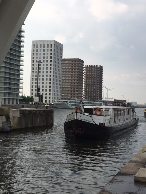
The Clair de Lune
Age (pronounced aghher) , a 65 year old former IBM project manager and our tour guide, met me at the boat and helped me aboard. I was introduced to Michael, the skipper, and Chris, the cook and second (and only) mate. In the next few hours, I met my fellow 16 travelers, 4 Australians, 2 South Africans, 2 Germans, 8 Brazilians and me. Between us, there were 2 doctors, a dentist, a pathologist, a leukemia researcher, 2 lawyers, a nurse, an engineer, a teacher, a pharmaceutical consultant, some housewives and 2 businessmen. The youngest was 44; the oldest 72. It was a congenial group although the Brazilians were not the best at being punctual, which drove the Australians crazy. Best of all, not a single smoker.
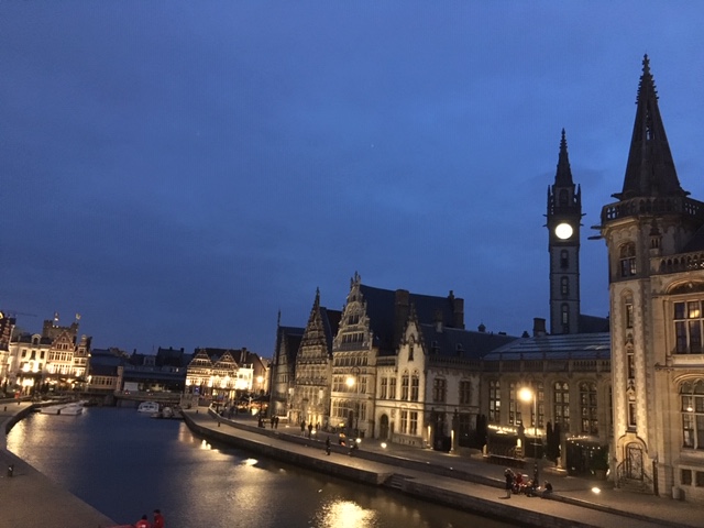
After Chris served us the first of many hearty meals, Age fitted us on our bikes and we rode 5 kilometers to the center of Ghent, where we had a brief guided tour. As was becoming the custom in the Belgian cities visited, there was a marvelous belfry near the town square, a Cathedral, too many churches to count and 2 old castles, all nestled between ancient canals and cobblestone roads.
Ghent by night
Most of the group took the train to Bruges the first day, but since I had just spent 4 days there, I chose instead to walk around Ghent. I visited Grovensteen castle, where the audio guide seemed focused on its builder’s (Phillip of Alsace) inability to procreate and the various means of torture and execution preferred in medieval times. An entire room was devoted to medieval torture instruments, making current interrogation techniques seem kind and gentle.
As Ghent is a canal town, a canal boat tour seemed in order. Five minutes after embarking, the skies opened up and the rain cascaded upon us. The boat operator/tour guide spent most of the time racing under one bridge to the next, but did provide a good history of Ghent’s golden age. Like Bruges before it and Antwerp later on, its fame in the Middle Ages came from its strategic location on a river that led inland from the North Atlantic, becoming a trading centre as its multitude of still existing warehouses attest, and wealthy from the tolls collected from the use of the canals.
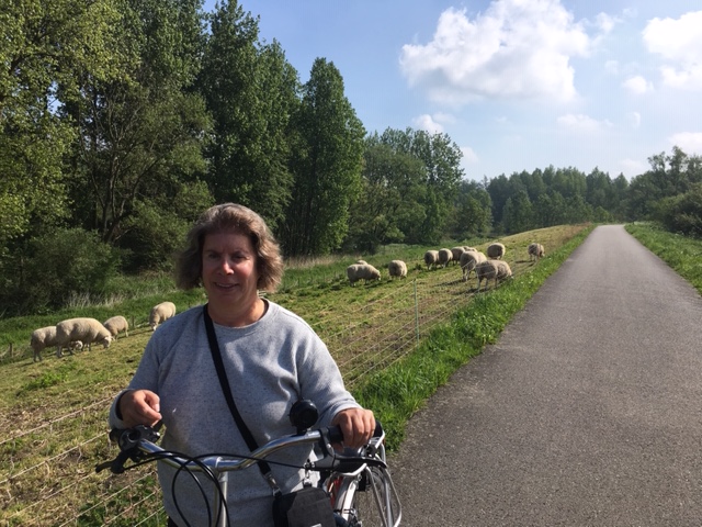
The next day was our first real cycling day – 50 kilometres to the city of Dendermonde – alongside lazy canals with lovely, secluded bike paths running on each side and the occasional pasture where sheep or cows grazed. Age led the way, wearing a yellow vest, with one of us appointed the sweeper each day whose job was to also don a yellow vest but always be last. If Age could see the sweeper, we were good. If not, we stopped until the last joined up. The Brazilians were intent on documenting every second of their trip, so they made frequent photo stops, took pictures while cycling, raced ahead to film the cyclists coming forward and after a while, even the ever patient Age asked them to reduce their photo stops. Once that was sorted out, the group cycled at a reasonable pace, only about 10 kilometers an hour with a 45 minute coffee break, lunch and small pit stops near interesting things where Age would share some aspect of Belgian history or lifestyle with us. No one tried to race and everyone kept up the pace.
Me, the bike and lots of sheep
Dendermonde was a pretty, medieval town like the other Belgian ones we toured without the name recognition of Bruges or Ghent. The next morning, we set out for Antwerp, arriving there after 5 hours on our bike at 3:00PM, much earlier than our barge which had been held up at a lock which refused to fill with water, then by rush hour traffic in Antwerp during which the harbour master wouldn’t open the drawbridge to let the boats through. It was a good opportunity to sit outside and enjoy a glass of wine and watch all the Hasidim walk by – the only clue to Antwerp’s position as a diamond industry giant.
On day 5, we cycled across the border into Holland, with only a small concrete post marking the boundary and began our trek in search of windmills. Soon enough, we arrived at Kinderdijk, the place of 18 windmills and a bustling tourist attraction, with busloads of Asians doing their European highlights tour and river cruise excursions bringing scores of Americans to the Visitor Center, both likely part of a concerted effort to get tourists out of the overly crowded Amsterdam. The mills themselves were beautiful against a backdrop of cloudy skies and the video, which explained the purpose of the windmills (water level management) and their mechanics, informative.
The Windmills at Kinderdijk
From Kinderdijk, we cycled to Gouda, home to Gouda cheese. The barge was moored close to the main square, which again was charming, with a town hall and medieval hall which weighed the cheese and other goods for tax purposes. I located a cheese store and sampled all their different varieties of Gouda- green pesto, black lemon, almonds – before settling on a medium, an aged and a spicy red pepper one and posing for the obligatory picture holding a (plastic and hollow) round of cheese.
Day 5 had been all about windmills and Gouda cheese; day 6 was devoted to tulips. Our trip had been advertised as a tulip tour; unfortunately Mother Nature had the final say. Thanks to a prior week of glorious sunshine and hot weather, most of the tulips had blossomed early and the farmers had cropped their fields already. We were able to locate a few still carpeted with flowers, where everyone sang Tiptoeing through the Tulips and took pictures, but the best display was at the Keukenhof, botanical gardens outside of Amsterdam ablaze with tulips of all colours and varieties. The tulips there are planted sequentially, ensuring a longer bloom. The gardens are massive; I spent 3 hours there and wished I had more time.
We cycled to Amsterdam and met the barge for one last city stroll, dinner and an evening of drinking and exchanging email addresses. We had cycled about 250 kilometers, endured 2 flat tires, 1 bike falling into the canal (but fished out again) and 2 falls where the worst damage was some scraped knees. The bike and barge had been a nice way to see Belgium and The Netherlands. People were uniformly friendly along the route, the pace relaxed and I felt that I was able to see some of the “real” country.
I was reluctant to do much touring in Amsterdam. I’ve been here before and the crowds are unreal, but I couldn’t resist a canal boat ride, some pancakes, some brownies and stopping in at the Rijksmuseum to see the All Rembrandt show, featuring all of Rembrandt’s paintings and most of his sketches. I enjoyed it so much I abandoned my pledge not to visit any more art galleries and went across the road to the Van Gogh museum. It exhibits his early paintings in Amsterdam followed by his Impressionist period in Paris through to his madness and ultimate suicide in the south of France. The gallery does an excellent job of explaining Van Gogh’s paintings through his interests – whether about religion, nature or the peasant lifestyle – and his influence on his art friends and later painters.
After 5 weeks in France, Belgium and The Netherlands, where it seemed to rain for all but a few days, I am off in search of sunshine in Croatia.
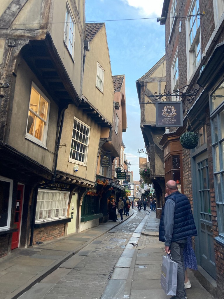
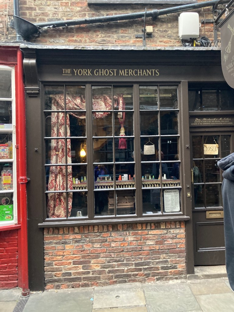
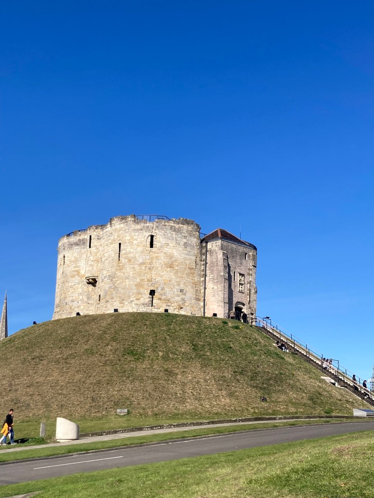
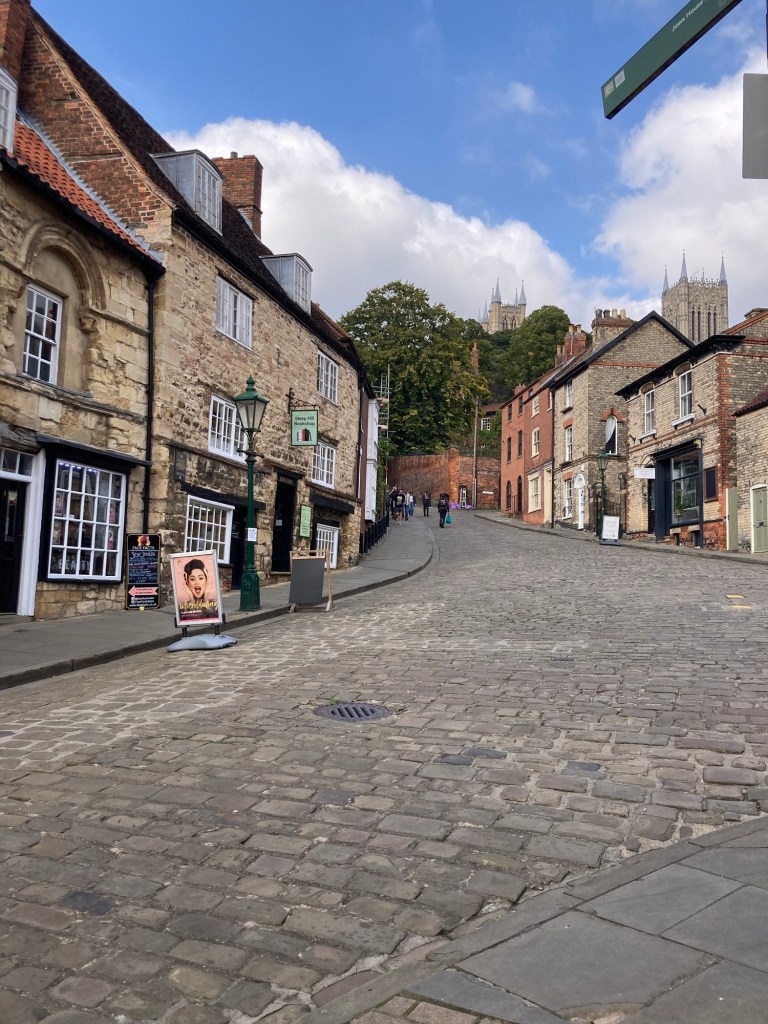
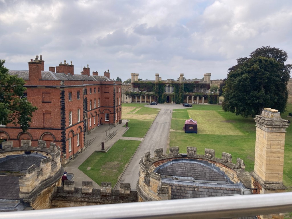

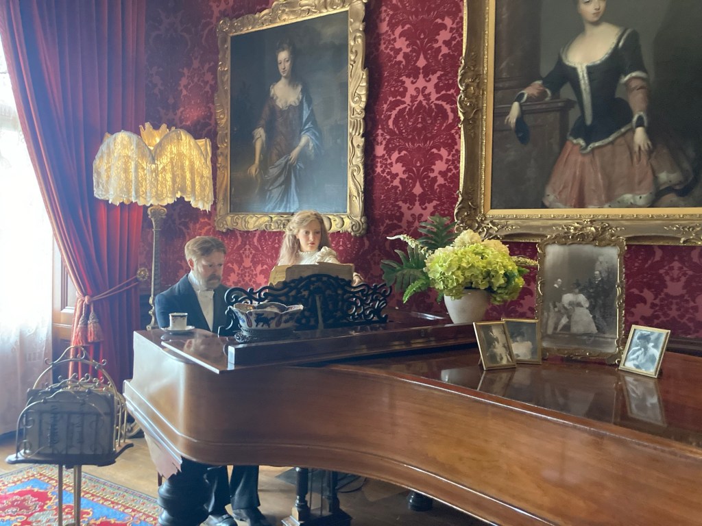
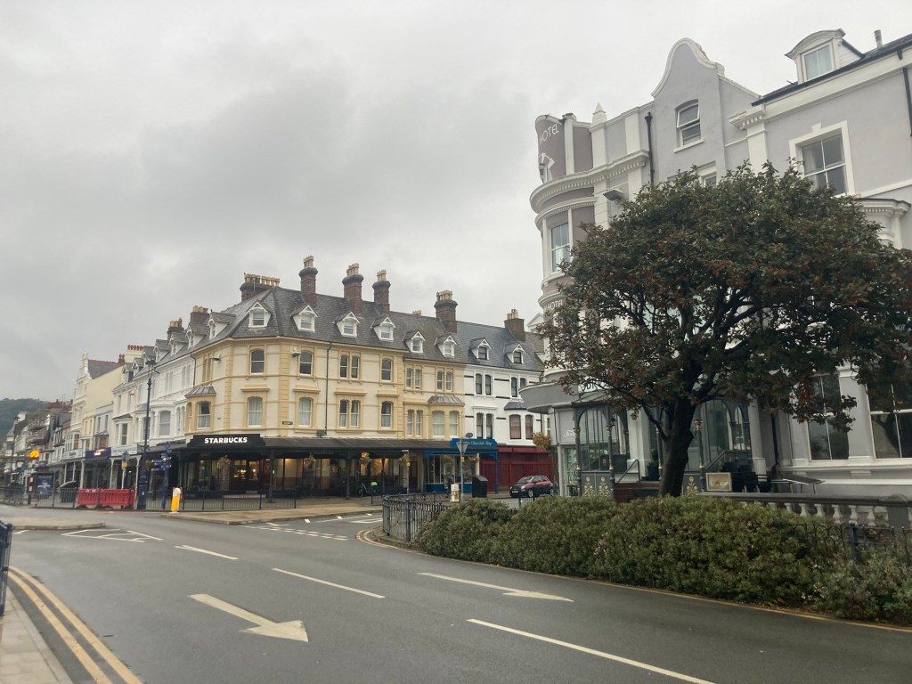
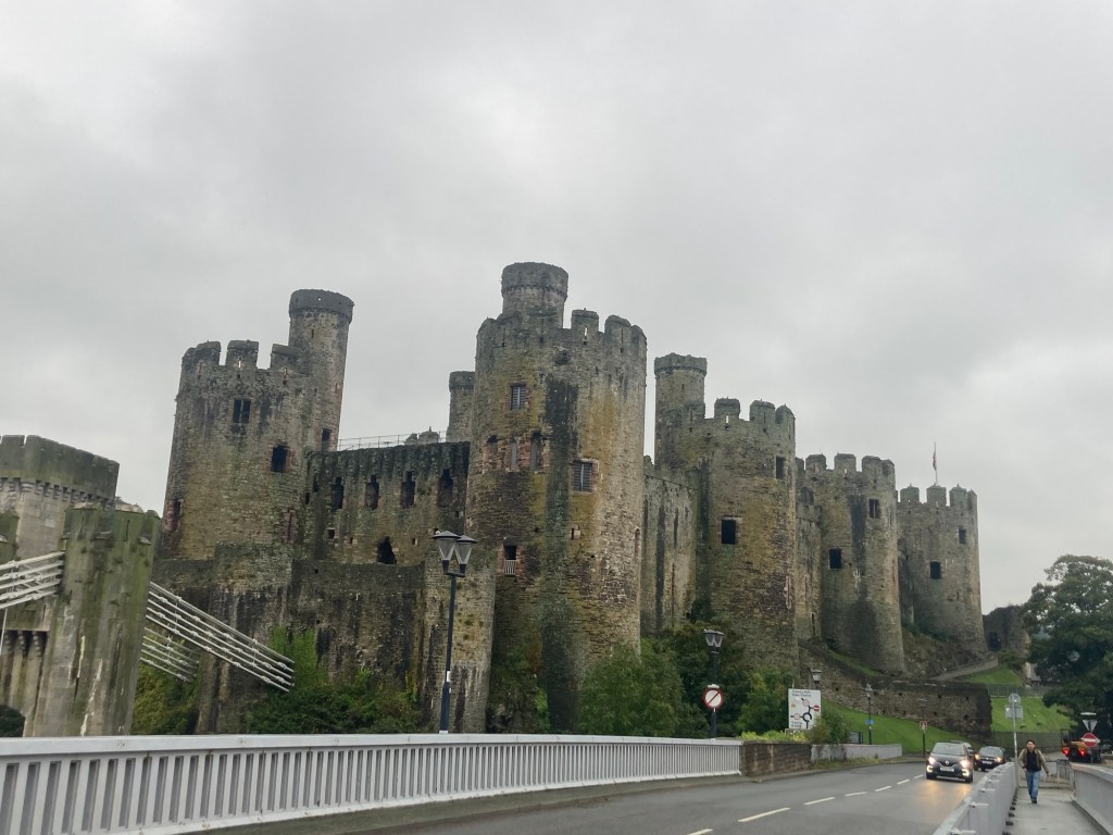
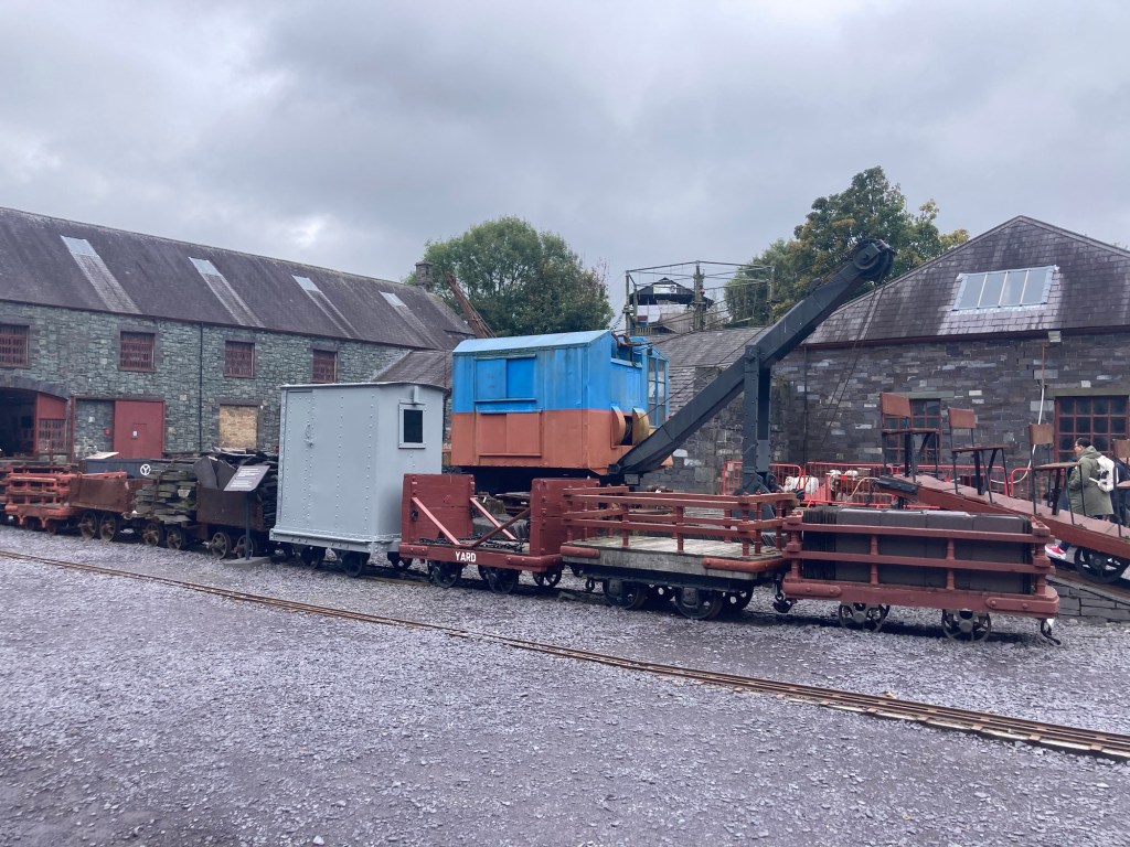
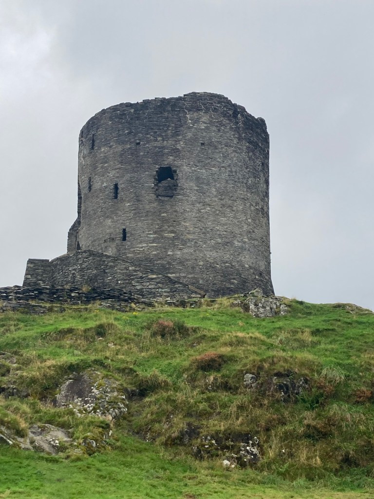
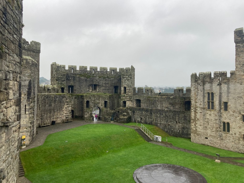
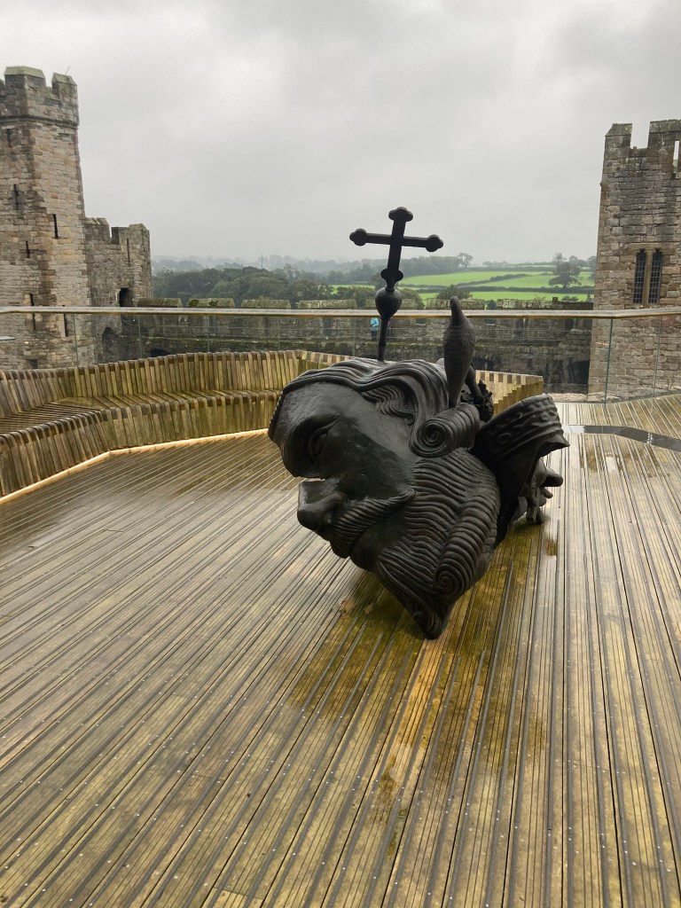
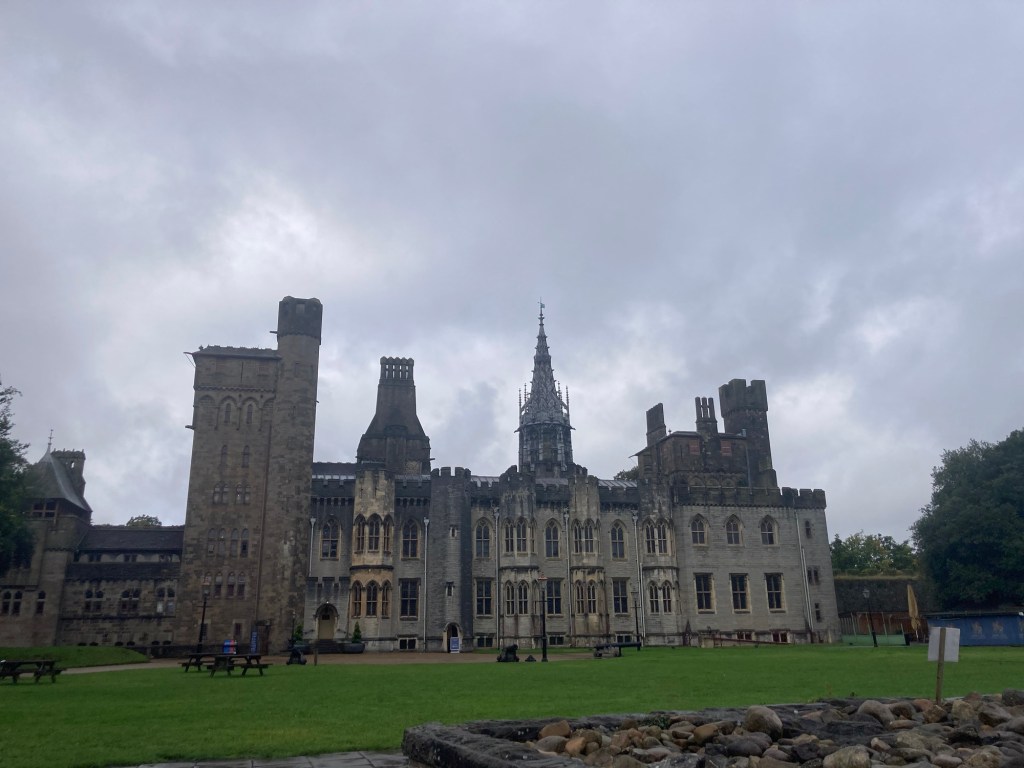
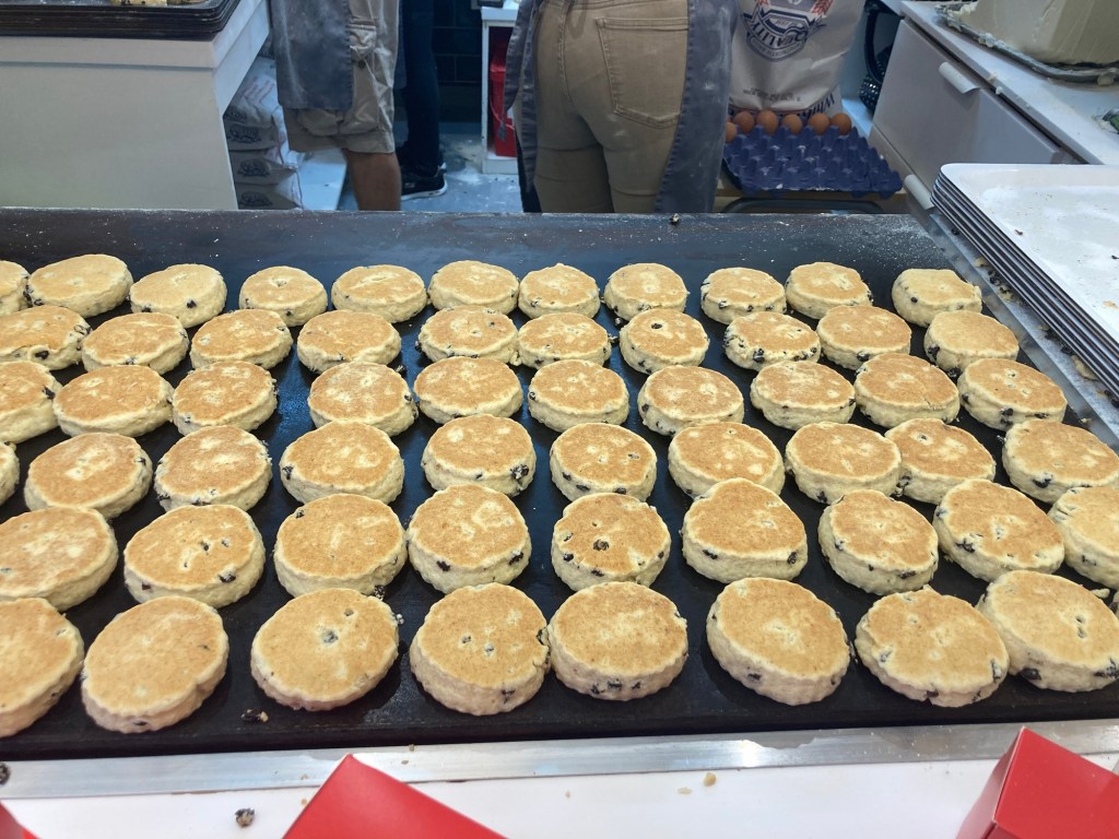
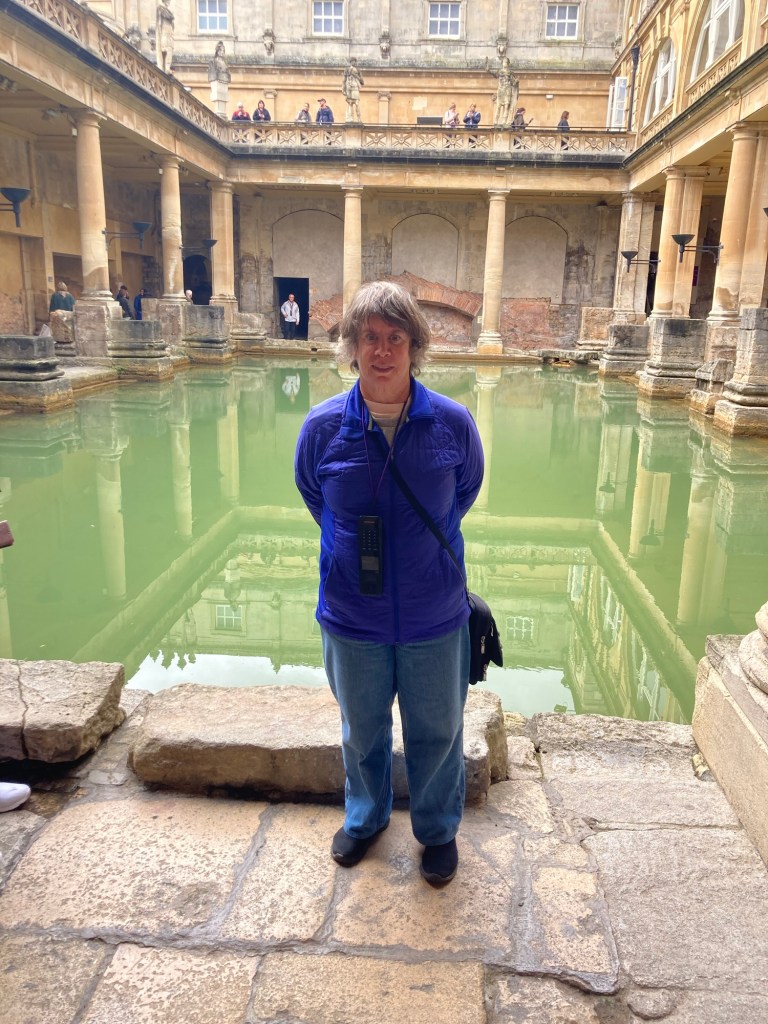
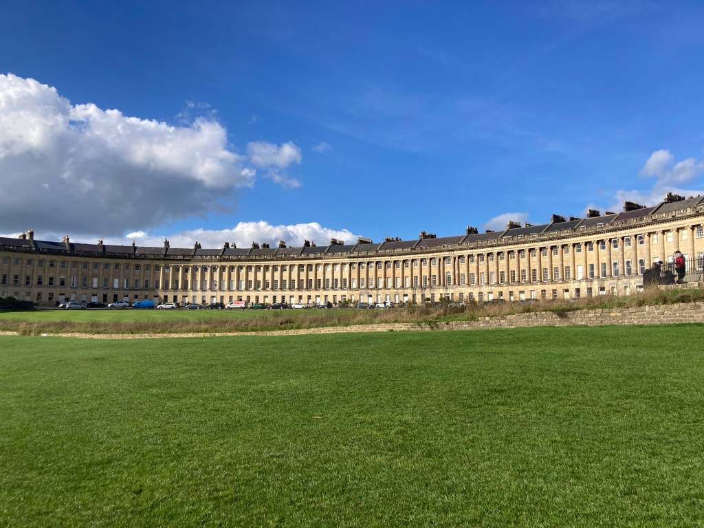
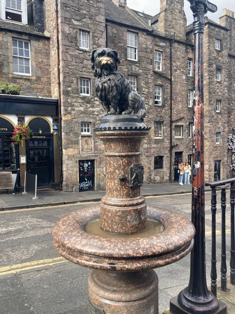
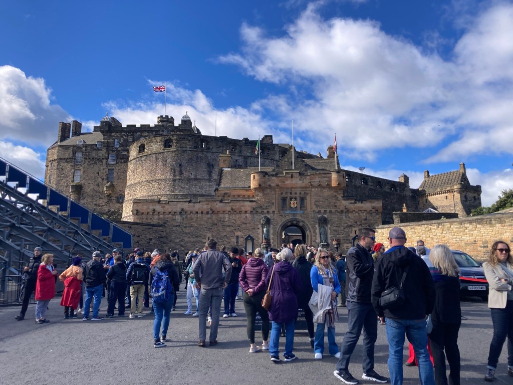
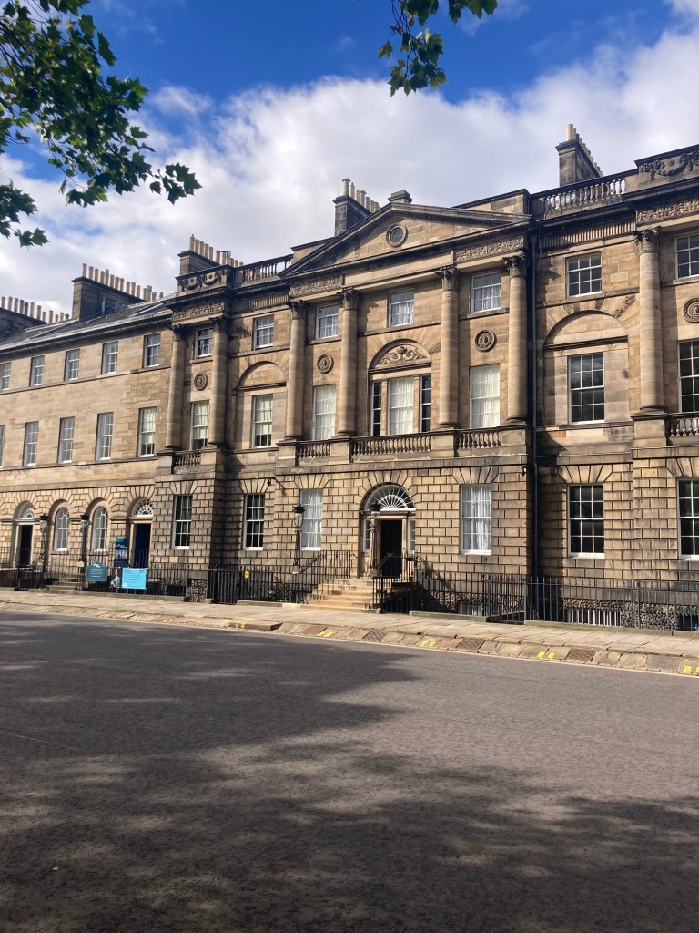
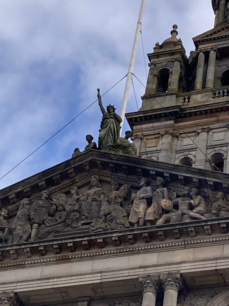

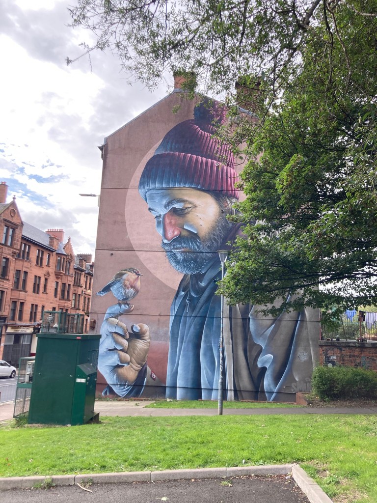
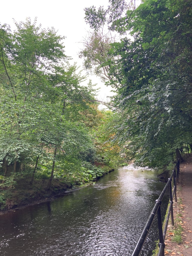
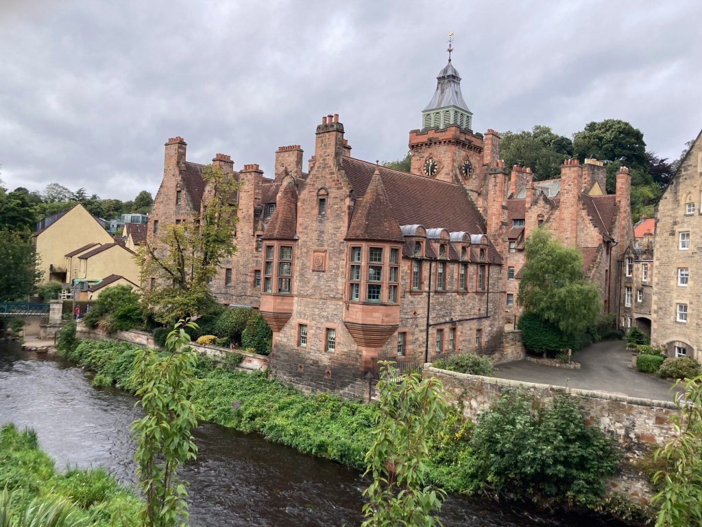
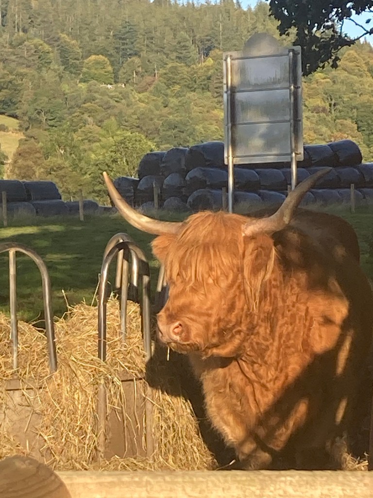
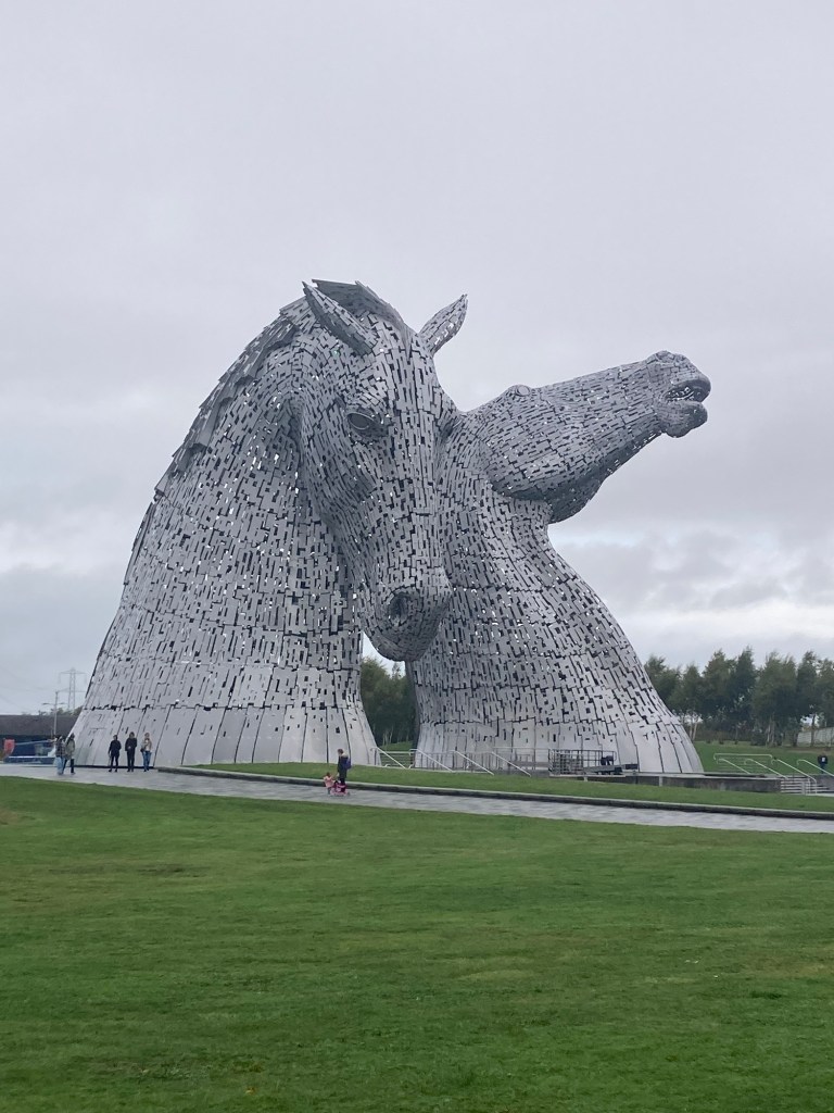
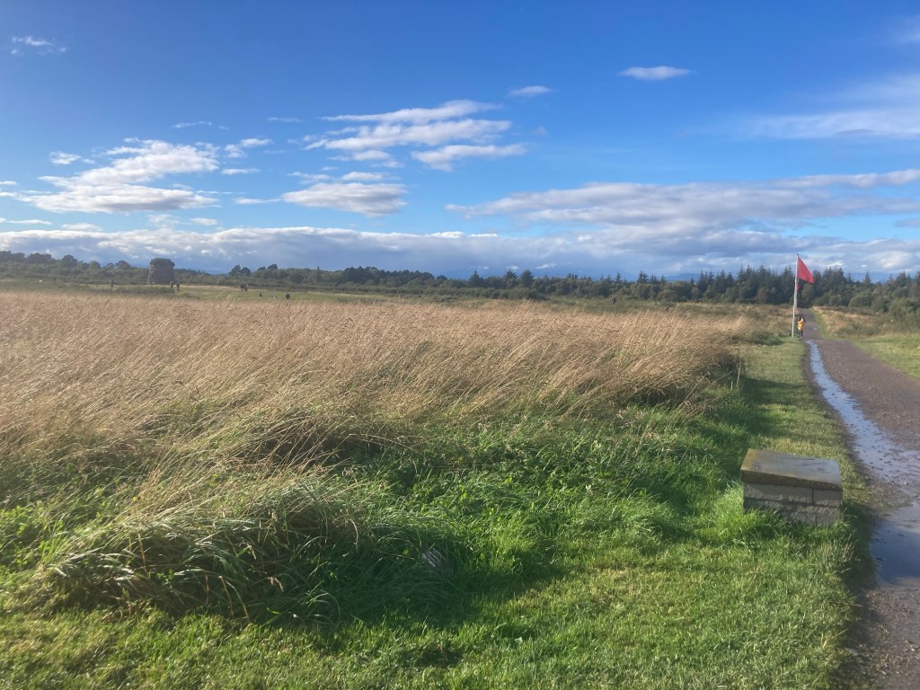
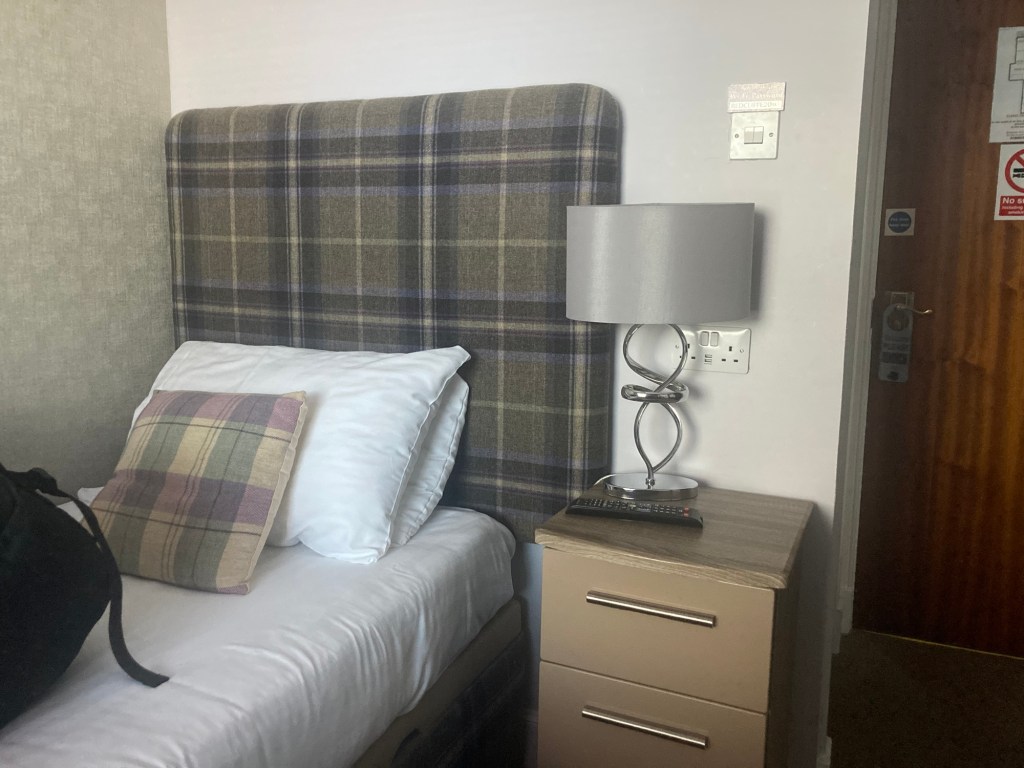
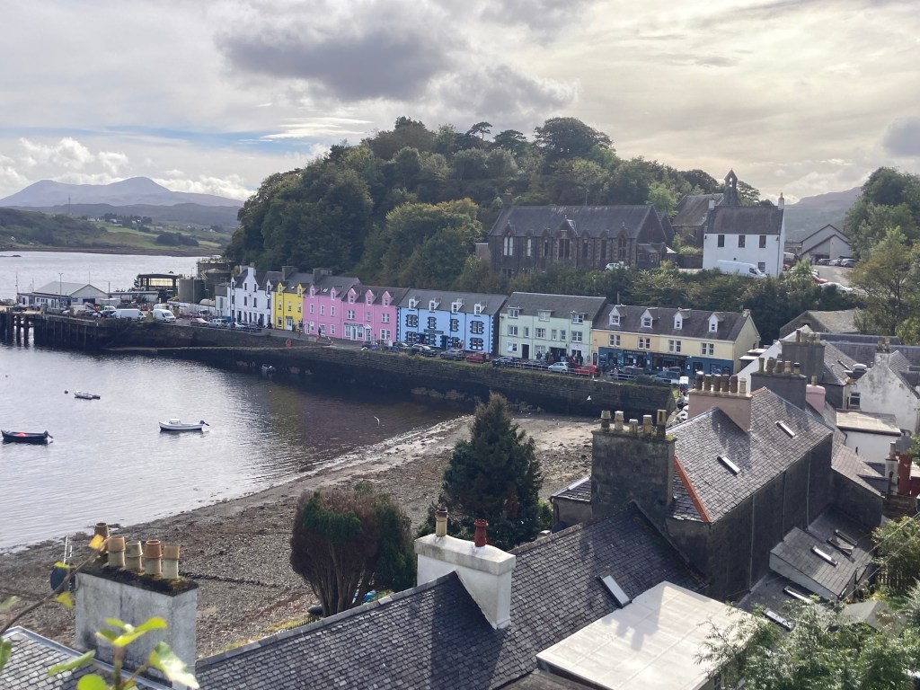
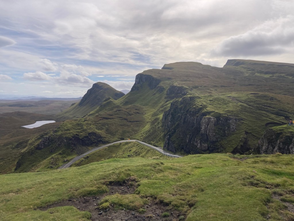
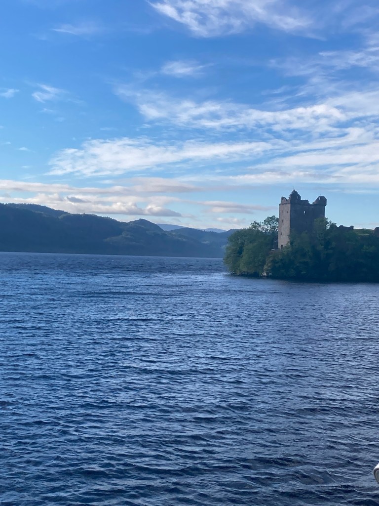
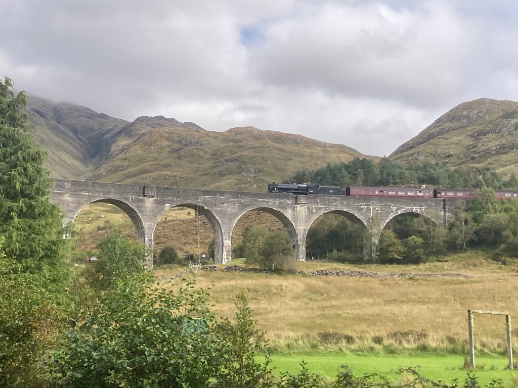

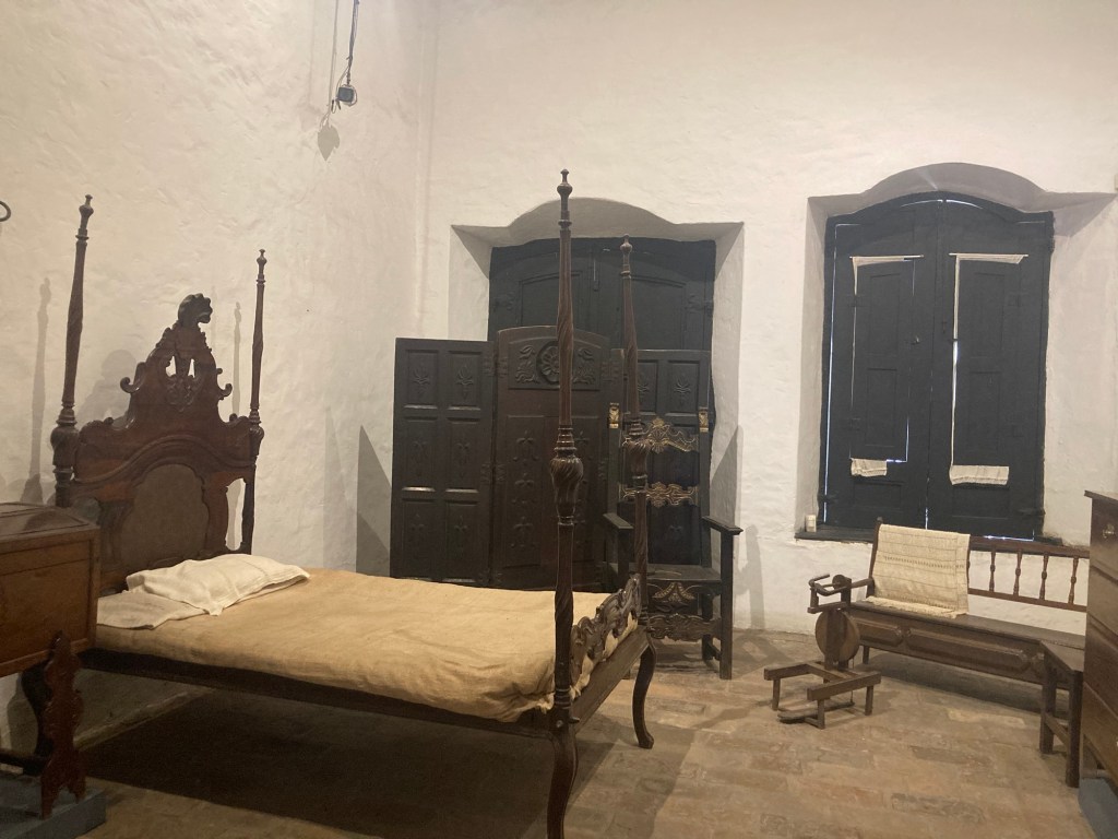
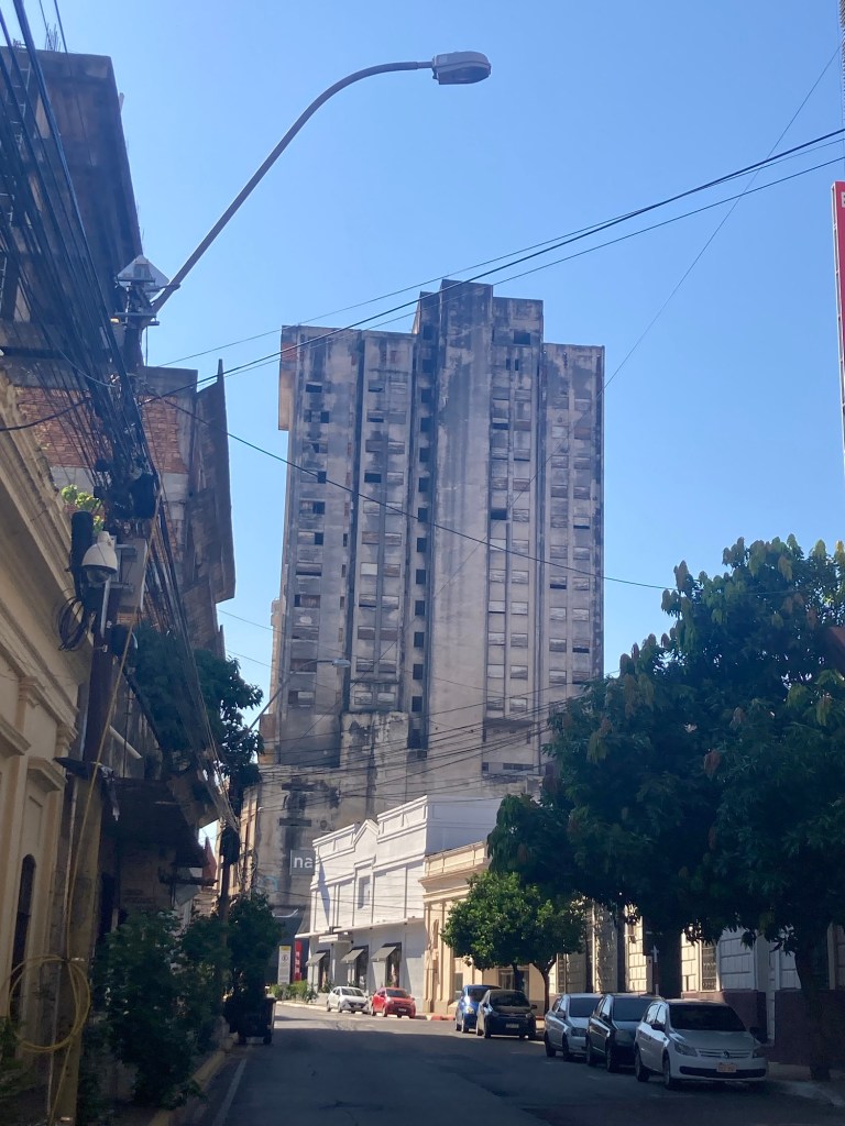
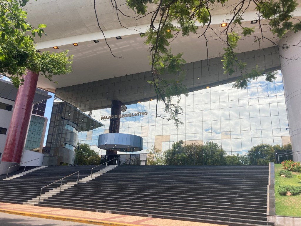

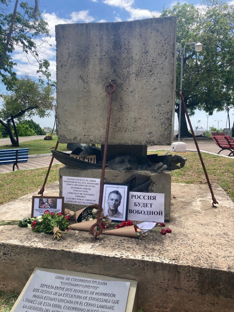


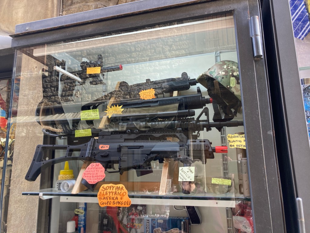

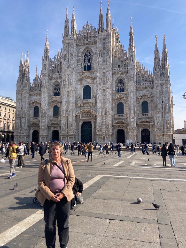
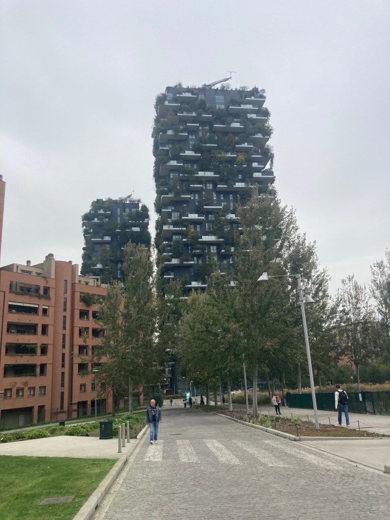
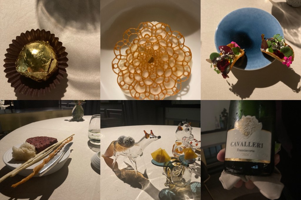
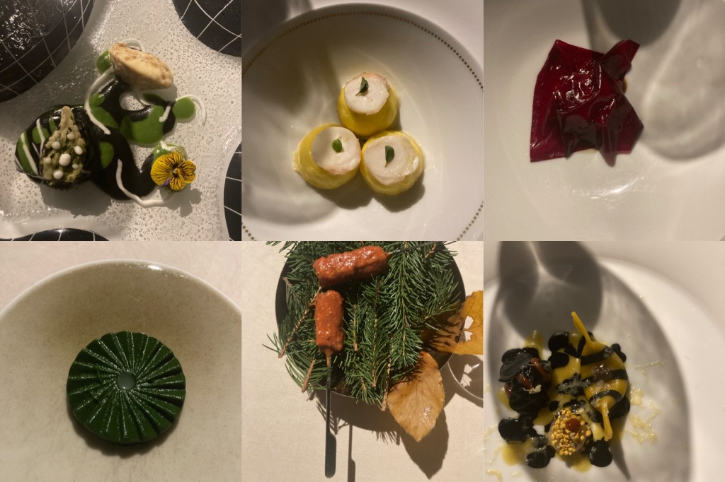
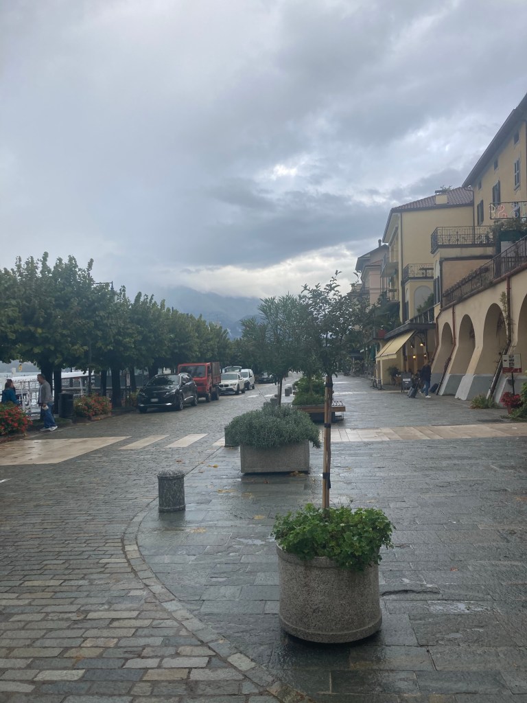


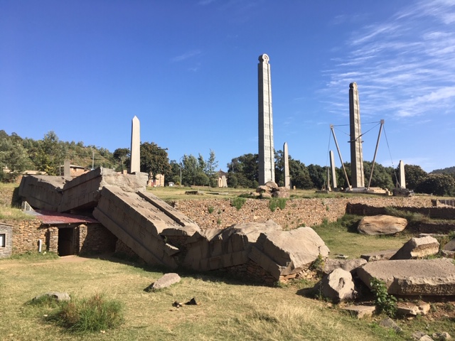
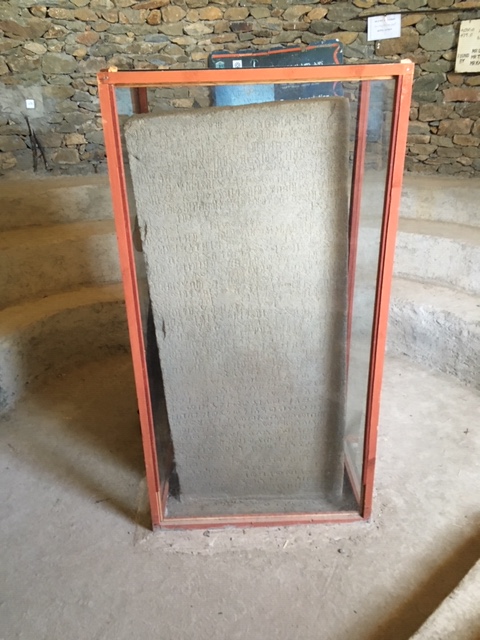
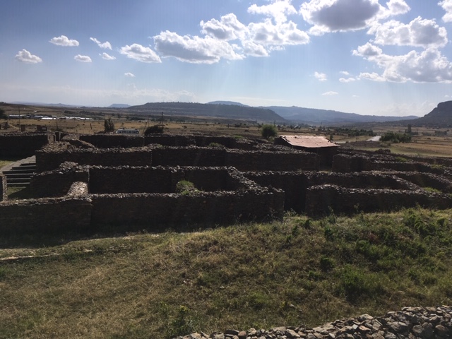


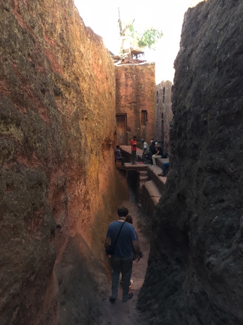
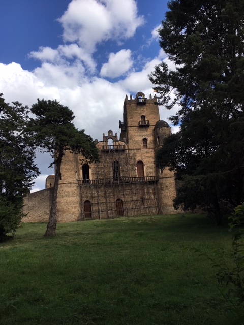
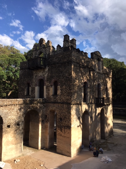


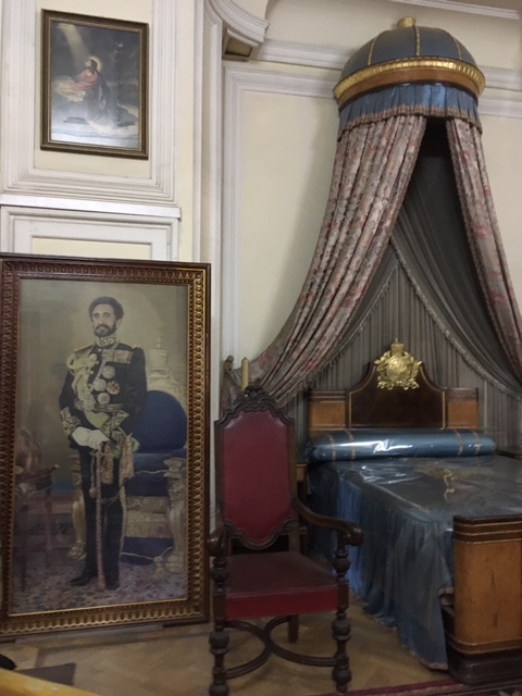


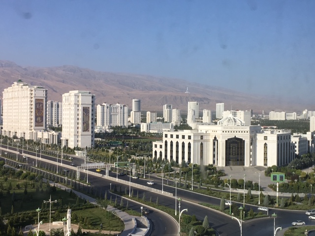
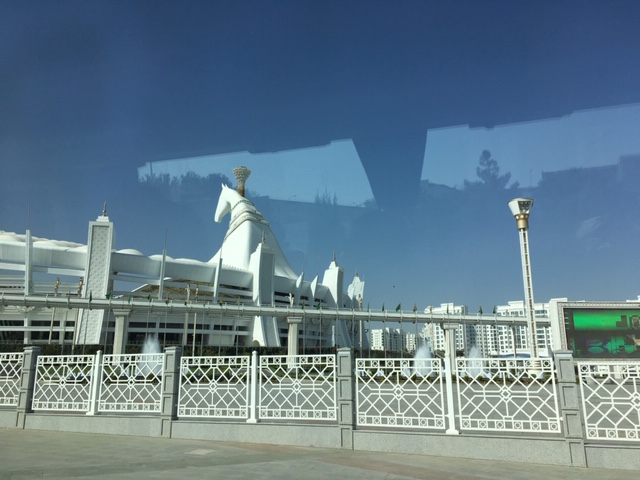


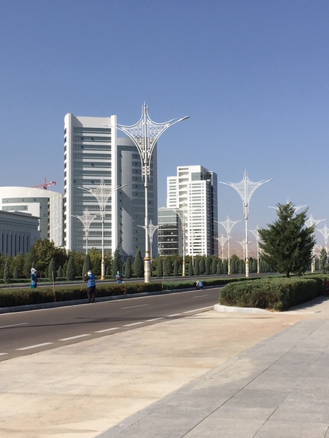


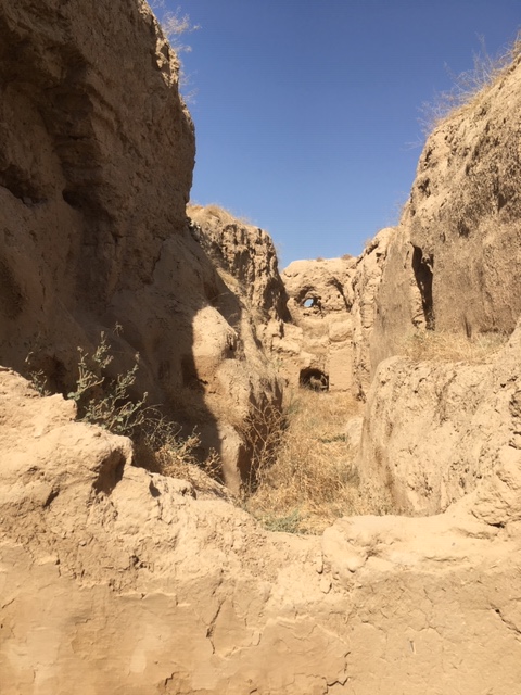
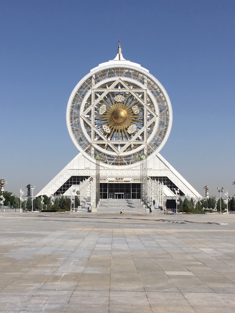
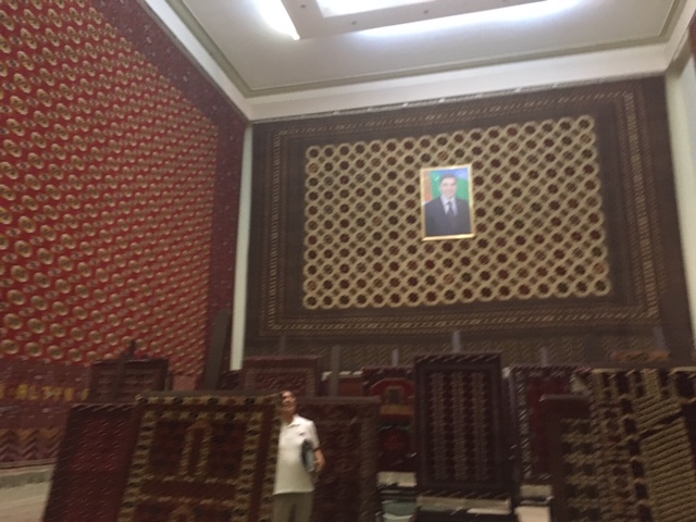
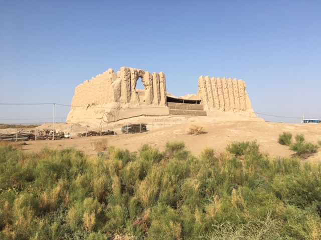
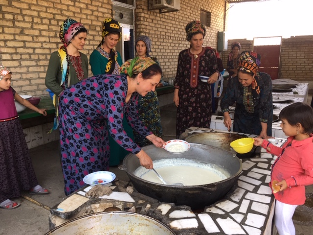


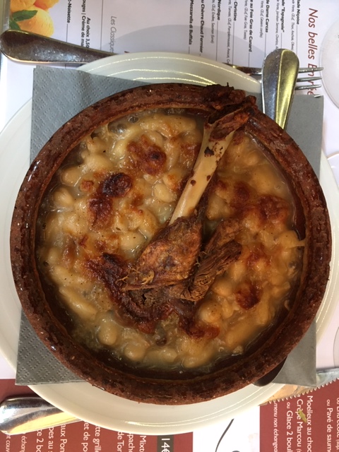

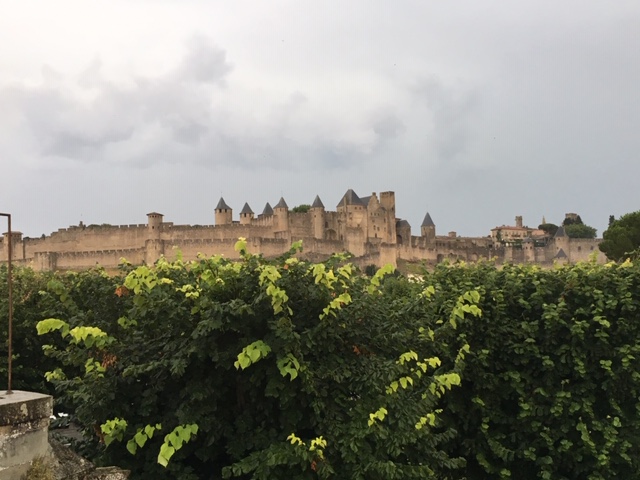


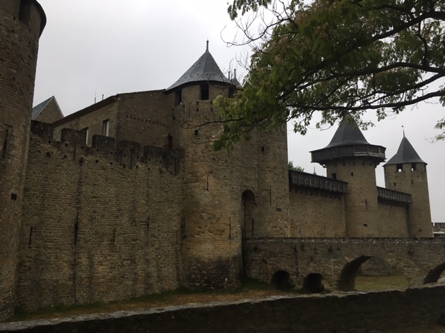
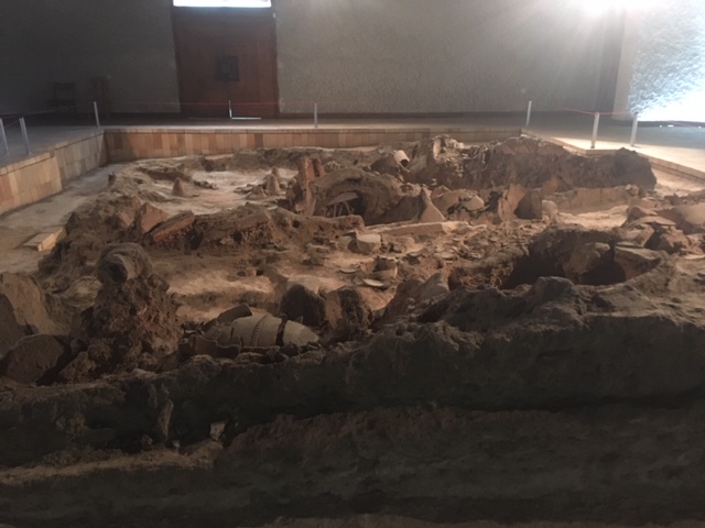


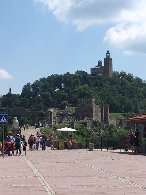


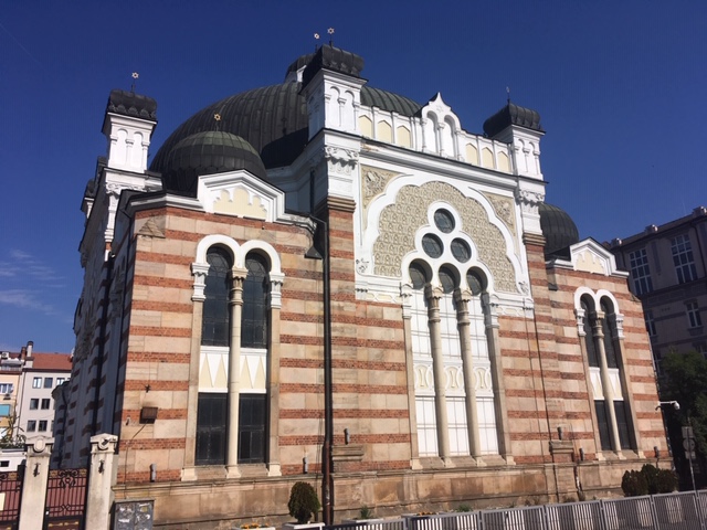
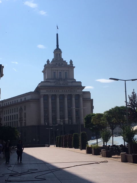
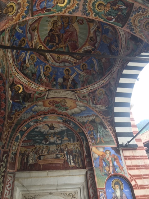
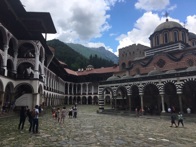


")