Brittany Highlights

After 3 weeks in the region, I will be reluctantly leaving Brittany tomorrow. The area is beautiful, replete with rolling green fields bordered by wildflowers, sandy beaches along the Atlantic coast and enough villages and cities filled with medieval timber frame houses, gothic churches and majestic castles. It’s a history lover’s dream – with its population proud of its Celtic (we are not French, they reminded me) roots, Arthurian ( of the British King Arthur) connections and a bevy of new world explorers, privateers and slave traders.

The people I met seemed more relaxed than in Paris; maybe it’s the small town mentality or the lack of hordes of tourists. People were patient with my attempts to speak French and instead of telling me they spoke English, most asked me if I would like to them to speak English. Walking the streets was a pleasure. Cars stopped to let me cross the street if I so much as looked at the street, zebra stripes or not. At the abundant pedestrian crossings, without fail, every vehicle stopped to let me pass. Cycle paths were plentiful, unfortunately so were hills. That, along with solid rain and cool temperatures, limited my enthusiasm for cycling long distances in the region.

St. Malo:

Following a long day of cycling to get to St. Malo, my legs were in no shape to get back on a bicycle, so I spent the day exploring the city.  The town earned its fame as a maritime city, its Atlantic shores blessed with bountiful supplies of fish and crustaceans. Early inhabitants were fishermen, later it became a center for shipbuilding and exploration. Both Jacques Cartier and Sebastian Cabot set sail for the new world (although Cartier was aiming for China) from here, eventually landing in Newfoundland and Quebec. In the 17th century, the port became wealthy with loot earned by privateers capturing gold laden ships departing South America. Today, in addition to its fishing booty, cruise ships dock here and disgorge their passengers who mostly race out of town on pre-paid shore excursions to nearby Mont. St. Micheal.

St. Malo has a glorious castle and ramparts. The castle’s foundations date to the 6th century AD, but its current reincarnation was built between the 15th and 17th centuries, Today, it is a museum showcasing the city’s history,  with the exhibits only in French , so my comprehension was limited. But the real star was the building, medieval with thick stone walls, tiny arrowslits and an entrance to the tower roof, where a view of the city and the Atlantic awaited.

IMG_5555
The walls and castle at St. Malo

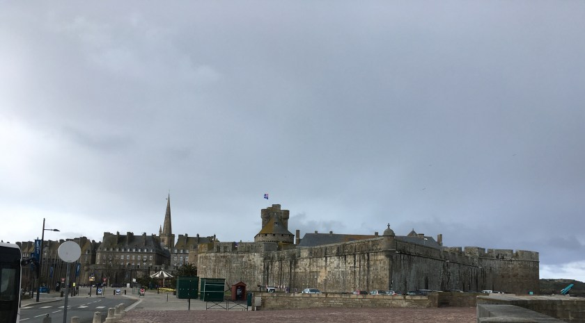
The ramparts, or walls, encircle about 2/3rds of the old city and were a pleasure to walk, with pathways as wide as 10 feet and paved in large tiles, rather than cobblestones awaiting to trip the unsuspecting walker. Strolling atop the ramparts, all of the architectural features of the city were on display: reconstructed 18th century houses (the city was heavily shelled during WW2), the castle, Fort National built on an island in the ocean, a lighthouse, watchtowers and an outdoor Olympic size swimming pool. Statues of local celebrities dot the path, including at least one honouring a privateer,  a fancy name for a state sanctioned pirate.

Today, St, Malo is best known as a beach town, with two beautiful white sand beaches bordered by pleasant walkways. Maybe it was too early in the season, but there were no signs of the tacky fish & chip shops and salt water taffy stands that deface the British seaside resorts I know (Margate comes to mind). Instead, there were creperies and brassieres (bars). Even the merry-go-round was quaint, reminiscent of a 1920’s model with pink horses and golden curlicues decorating the edges.

St. Malo is also famous for its seafood – oysters were for sale everywhere – and boat signs announced they had a fresh catch. Restaurants promoted their “fruit de la mer” and I couldn’t resist. After playing it safe with a St. Malo filet (dory) one night, the next I braved the seafood platter. With apologies to my Jewish family and friends, the offerings included oysters, escargot (snails), prawns, whelks, crabs and some things I couldn’t identify.

IMG_5670
Seafood platter in St. Malo

I gave it my best, but the oysters were really salty, the escargots chewy and tasteless, the prawns were fine but mostly bone and very little meat. Having tried at least one of everything on the platter, finishing the prawns and crab legs, I was still hungry, so I had my favourite part of the meal – the pumpernickel-like bread with butter.

Mont. St. Michel:

Beautiful bike routes of about 50 kilometers exist between St. Malo and Mont. St. Michel and my original plan had been to cycle there, but the previous day had seen hail and the day’s forecast was for rain. My bike stayed in storage and I took a train to Dol de Bretagne, then the bus conveniently waiting at the train station to the Mont. St. Michel visitor center to catch the trolley that dropped me and the other waiting tourists to within 500 meters of the island. From there, we were left to walk, using the causeway, or drop down to walk across the sand but as one could only walk on the sand with a licensed guide. I stayed on the causeway.

After entering through the walls, a winding narrow cobblestone alley with shops and restaurants on either side leads, after a heart pounding climb, to the abbey proper. I followed the audio guided tour through the abbey. Originally constructed in the 8th century, it has been rebuilt, expanded and reconstituted over the centuries. Inside are chapels, cloisters, greeting rooms and studies, most open to the public. The decoration was less elaborate than other churches I had visited – no stained glass windows or tapestries – but impressive in its simplicity.

I emerged to a thunderous storm and made my way down the street, ducking into one of the many overpriced restaurants selling Mont St. Michel’s specialties – galettes, crepes, and seafood- and enjoyed a Mont. St. Michel omelette, which was  fluffy with a light cream sauce.

Mont. St. Michel is impressive, but its most awe-inspiring aspect for me was that first glimpse, of the abbey and spire pointing to the heavens, atop an island. I walked the 3 kilometers back to the visitor center, frequently turning back for another view and a picture of the island.

Morlaix:

Five days into my 3 week long cycling trip, I’d given up on long distance cycling, but the town (15,000 residents) of Morlaix on an estuary for which I could not find the name (everyone said “the Morlaix harbour” but it wasn’t a harbour as I understand the term) had lots of bike paths. It’s a pretty town, with 123 timber buildings, numerous churches, a viaduct built in 1861 for trains and way too many stairs, which I did my best to avoid.  I stayed in the 200 year old Hotel L’Europe. Morlaix has long been a haven for ships, with the unnamed river/estuary only 6 kilometers from the ocean, but it became rich in the 15th and 16th century thanks to its manufacture of tobacco. An exhibit at the former tobacco manufacture plant explained the relationship of Morlaix to this industry and boasted that Morlaix had the largest number of smokers in France in the 1990’s. The plant is now an arts school and no cigarettes are made in the town anymore. Sadly, pretty as Morlaix was, its former market square had been turned into a parking lot.

IMG_5729
Morlaix, with the viaduct and former market square

Roscoff:

Roscoff is a small city on the Atlantic about 28 kilometers from Morlaix. My desire to cycle there was met with the dilemma of too many options. My Voies Vert (green routes for cyclists) book had one route, GoogleMaps another, maps.me a third and the signs with a green bicycle saying “Roscoff” pointed to yet another. I choose to follow the green road signs, which didn’t mention the route is probably good training for the Tour de France, with way too many steep climbs for my liking and a few off-road treks through farmers’ fields ripe with the bright yellow blooms of canola or smelling of manure. The signs were relatively easy to follow- only one wrong turn easily remedied when the  path led straight into the ocean – and less than 4 hours later, I arrived at my destination.

Roscoff is primarily a fishing and pleasure boat center, having no discernible beach. Its buildings spanned the centuries, its main church topped with a unique spire emphasizing its square building blocks, and plenty of restaurants lining the marina. I stopped for a typical Breton pastry, the Kouign-Amann, which is butter and sugar added to a croissant-like dough. Not great for dieters, but warmed-up, it was the perfect reward for a long bike ride. After demolishing one in quick fashion, I took a look at the brewing storm clouds and began the long ride back to Morlaix. I was drenched by the time I made it back, but nothing a hot bath and a glass of wine couldn’t cure.

IMG_5681
Roscoff

Dourduff:

The one thing I figured out about cycling in France is the route along the river or canal is likely to be flat. With that thought in mind, I cycled the 6 kilometers on the very flat roadway beside the still unbeknownst to me named river from Morlaix to Dourdoff. Despite the roadway being a minor (“D” series) highway without shoulders, the drivers were ultra considerate, always swerving generously to leave me wide berth, sometimes even slowing behind me for a few minutes until the center line became broken and passing was again permitted. Dourduff itself is fairly non-descript but offers beautiful views of the Atlantic.

IMG_5701
Dourdoff, facing away from the Atlantic

Brest:

Brest is a coastal city on the southern edge of Brittany, so I was expecting another charming seaside town, perhaps with a beach or two and an abundance of architecture. Unfortunately, as my train approached and I read up on the city, I learned that it had been, and still was, the headquarters of the French navy.  Thus, it had been bombed to smithereens in WWII; only a single original castle housing a maritime museum (in French only) withstood the barrage. Today, 1950’s office and apartment buildings line the river and harbour, with high fences topped with barbed wire and signs (again in French) warning it is military property and beware of the dogs. Looking down into the river, I could see a vast array of military ships and submarines. It was not my favourite stop, but its main pedestrian road had a bagel store, called Bagelstein, which made me a very good smoked salmon with cream cheese and red onions bagel.

Quimper:

Quimper marked a return to the scenic, quaint town, traversed by the canal along the Odet river and highlighted by the Saint Corentin cathedral, another gothic cathedral, this one dating to 1239. Architecture in the town again spans the centuries, with an unique Art Nouveau theater. Quimper and its suburb of Locmaria gained fame for its arts & crafts, especially its Faience pottery, for which there is a dedicated museum that is pleasant and informative. Feeling quite touristy, I took the tourist train for a ride around the center and, as the history buff in me demanded, visited the History of Quimper museum, with a large display of stone and Iron Age implements.


Nantes

Nantes, a city of 300,000, is the administrative seat of the Loire-Atlantique region. Why it is not part of the administrative region of Brittany is a mystery, but it isn’t.  Situated at the last navigatable point where ships could sail upstream from the Atlantic Ocean along the Loire River, and having two other convenient estuaries, it has a long history as a major port city. Its center is dominated by the Château of Anne, Duchess of Brittany, who had the good (or bad, depending on your viewpoint) fortune to marry two different kings of France, became a patron of the arts and completed the Chateau that bears her name. Entrance to its grounds, via drawbridge across a moat and around its ramparts, was free; the history museum charged but it was worthwhile. Although it detailed Nantes’ long legacy, the most informative displays recited Nantes’ role in the African slave trade.  Nantes’ ships sailed to Senegal, picked up slaves, sold them in the West Indies and returned to Nantes laden with mostly sugar cane, but also tobacco. Nantes wealth – its soaring gothic Cathedral (started in 1434 and not finished until 1891), its canals, its streets and public houses were largely financed with profits made by the slave traders. France abolished slavery during the French Revolution, but Napoleon reinstated it. It was outlawed for good in 1831.

IMG_5785
Entrance to the Chateau to Duchess Anne

Nantes, more than any other city in Brittany, prides itself on its forward thinking. Many of its buildings represent cutting edge architecture – my hotel had large orange and turquoise green pieces of plexiglass decorating its exterior, maybe resembling sails or maybe the colours of the football stadium which it adjoined. I don’t know. Nantes’ most lauded artistic achievement is Les Machines de l’Ile, a former shipbuilding site that artists turned into a place to construct and exhibit interactive plants and animals made from machines. The crowd favourite is the 3 story high, Grand Elephant, which carries passengers about and can spout water from its trunk.

IMG_5816

And so, with a mechanical elephant, I end my days in Brittany.


Cycling in Brittany

Dervla Murphy, an Irish octogenarian, is one of my favourite travel writers. In 1965, at the age of 30, she hopped on her bike and cycled to India, sleeping rough or in hotelis or truck stops for 1 pound a night, indulging in her preferred beer, Tusker, at least nightly and encountering an amazing number of English speakers willing to engage in far ranging conversations from politics to AIDS that frequently made their way into Ms Murphy’s books.  Her globetrotting cycling  through Africa, Asia and the Middle East and, with her young daughter, over the Andes by donkey, continued until Siberia in 2010 – which proved her undoing – after a fall damaged her knee, she gave up the bicycle but continued her voyage by train and bus, again resulting in an highly entertaining travel book.

She was my inspiration, but I knew I wasn’t going to completely emulate her.  I don’t drink beer and my hotel requirements extend well beyond a room with a bed and door,  but I had planned to do a lot of cycling. The hilly roads in Paris where I stayed in the fall, along with the aggressive nature of its drivers deterred me from renting a bike there and, except for bike share rentals in Sweden and Australia, my resolve to do some serious cycling had thus far eluded me. Returning to France and cycling weather in April, it was time to remedy the situation.

As an avowed fair weather cyclist, I kept watch on the weather forecasts in the weeks preceding my return. The region of Brittany, or Bretagne as is referred to in France, was expecting sunny skies and temperatures in the 20’s. It is also known as a cyclist’s paradise, with numerous velo verts or greenways dedicated to cyclists. Plus, Mont. St. Michel, a place I had always wanted to visit, was within cycling distance. After one last check on the weather before I left Doha confirmed the favourable conditions, I booked a hotel in Rennes, a bicycle, complete with 2 panniers (saddlebags) and a water bottle for 10 days and another hotel in St. Malo, 67 kilometres, from Rennes.

When I landed in Paris 7 hours later, the weather forecast had changed dramatically. For the first few days, the forecast held, but on the day I was to bike to St. Malo, rain and temperatures in the single digits were predicted. I was not happy, but there was little I could do except channel my inner Dervla Murphy, who was never put off by a bit of rain, and make the best of it.

I spent two days wandering about Rennes – it is a beautiful city of 200,000, home to the region’s parliament building and a charming old town. Medieval houses, with timbers criss-crossing the exteriors, dominate the old town.

IMG_5481

The Cathedral was started in 605 and evolved over the decades from Gothic to classical:

IMG_5472

The medieval gates were under scaffolding, but the Park of Thabor, with its traditional French garden design (symmetrical rather than mimicking nature like English gardens) was in full bloom.

IMG_5489

After 2 relaxing days in Rennes, it was time to get serious and cycle to St. Malo. My bike was to be delivered at 9:00AM, plenty of time to beat the afternoon rain if the Google Map’s distance of 67 kilometres was accurate. But 9:00AM, then 10:00AM came and went without signs of the bicycle. After a number of increasingly heated phone calls, my bicycle was finally delivered by an apologetic man who spoke good English. He showed me how to lower the seat, work the gears, unlock the panniers and where the tire puncture repair kit was located. When I shot him a dirty look, he said :

“Not to worry, there are repair shops all along the canal which can help if you have a puncture. Besides, we have reinforced the tires to prevent punctures.”

“Canal?” I queried. “I am going to take the Google Maps bike route.”

“Oh, no, no, no, you must take the canal, Velo 2. It is so much more peaceful,” he explained.

“Is it any farther? I haven’t done a lot of distance biking lately.”

“Not so much farther, but so much nicer.”

“Okay”, I said, “you know better.”

And I was off. Finding the canal route was easy since it was 3 blocks from my hotel, and, as indicated in its name, by a canal. In fairness to my sense of direction, there were two canals so getting on the correct one involved at least a modicum of intelligence. The sign post saying Velo 2 also helped.

The bike route started out beautifully. As promised, there were no cars, except where the path crossed well marked roadways. A few barges made their way upstream. Birds – ducks, geese, cranes – chirped and swooped into the water, completely oblivious to a lone cyclist. Three kilometres out I ran into a sobering sight. Police and an ambulance were tending to a downed cyclist. I do not know what happened to cause his injuries, but it was not an auspicious beginning.

Less than 15 minutes later, another police car slowly made its way up the cycle path. I swerved to let it pass, but instead, it stopped and a 30ish year old officer rolled down the window and held up a machine that looked like a large phone with a man’s photo on it. “Have you seen this man?” I was asked, in French. “No, I haven’t seen him,” I replied still in French. “Merci,” he said, rolled up his window and drove on. “Wonderful,” I thought, “the police are doing a manhunt on my bike path. For all I know, there is a psychopath ax-murderer stalking cyclists and I could be next.” Shades of Strasbourg entered my head, along with recognition of my total vulnerability if someone should try to shoot me. At best, my cycling speed is slow and I was weighed down by two loaded panniers and gears I hadn’t yet mastered. There were few other people around – some dog walkers, a few joggers and the occasional grey haired rambler getting what seemed to be his or daily exercise, a couple of other cyclists on the path – and cars were rarely visible. No one who could take down a gun-toting murderer should he appear.

Since there wouldn’t be much I could do if someone decided to jump out and start shooting, there was nothing to do but put such thoughts out of my mind and enjoy the scenery. Verdant forests lined the path, with occasional wild flowers peeking through the grass. The birds provided a symphony of nature sounds, fish splashed up and back into the water. Despite the cloudy sky, rain fell only for a few minutes a couple of times. I cycled on, listening to the sound of the bike wheels crunching the gravel below. It was heavenly.

After 2 1/2 hours, I sat down on one of many conveniently located benches, close to more conveniently provided water dispensers and a bathroom (an empty campground was nearby), pulled out some cheese, a baguette, an orange and ate lunch. I checked my mileage, only to discover I had done only 30 kilometres. Exactly how much longer than 67 kilometres was this path? Google told me: 107 kilometres. 2-3 hours longer than 67 kilometers at my usual 15 kilometres per hour pace. At the rate I was going, , it would take me 9 hours to get to the end of the path, then be faced with a short ferry ride to St. Malo. I had better speed it up!

Regretfully, the path had other plans. It turned from gentle gravel to large rocks, uphill climbs and slippery downhill slopes on what seemed to me an old logging road, with felled trees and a detour away from the canal. Suddenly there were no people around and the skies finally opened and a torrent of rain let lose. All that was missing was lightning. I got off the bike and pushed it through the now muddy dirt and rocks until, after an hour, the path returned to the canal and the gentle packed dirt. But it was already 3:00PM and my mileage computer told me I was barely half way to my destination.

I considered my options, or rather Google Maps did. The path would take at least 5 hours at my current speed. But if I continued on the path for 45 more minutes, then turned out and followed the roads to St. Malo it would take just another 2 hours. It seemed like the better choice.

After leaving the path, with Google Maps informing my I was 2 hours and 10 minutes from my destination, the instructions from Google Maps got me lost 3 times in short order, once into a farm yard with a frightful looking dog who started barking loudly as I wandered into his territory and another time up the 2 biggest hills in Brittany. After cycling off the path for an hour, I finally saw a road sign for St. Malo. I checked Google Maps – my battery was just about dead and I still had 2 hours and 4 minutes to go! I would have to follow the road signs from here on in, but given how badly Google Maps had mislead me, this was not an unwelcome development.

I cycled on the “D” series of highways, pretty country roads without shoulders but with little traffic and slow speed limits. What they did have were mountains. Now my son would call them molehills, but to me, after 6 hours and not in the best of shape, they were giant obstacles. I did what any sane person would do, climbed off my bike and walked myself and the bike up the mountains. But, dammit, on the third such climb, my legs started cramping!

Seven hours later, with St. Malo still 30 kilometres away, the wind picked up, the rain fell non-stop and I had had enough. My thighs were cramping, not only on the climbs or the walks, but on the gentle cycles on the flats. A small town loomed on the horizon. What would Ms. Murphy do? She would push through to the nearest town, find a grubby room costing only a few pounds, locate the nearest pub, have a beer or two and bear down for the night. I had a not inexpensive prepaid hotel room in St. Malo, could not find a bar to save my life and do not like beer. With a great deal of pain and will power, I made it to the town, found the only sign of life at a training school for bakers of crepes and pizzas (I kid you not) and asked them to call me a taxi.

Thirty minutes later, the taxi driver drove me and my bike the 25 kilometres to St. Malo, took us on an impromptu tour of the town (the prettiest beach in the world he claimed ) and deposited me at my hotel.

Ms Murphy would not choose this ending, but it worked for me. A hot shower, 2 glasses of wine and a dinner of St. Pierre filet (dory) and risotto later and I was a very happy camper.


Cycling done right: Perth

Perth lies inland from the Indian Ocean, 22 kilometres upstream on the Swan River and about 3400 kilometres from the nearest city of any size- Melbourne – which is why it is known as the world’s most isolated city. It is clean and modern, blessed with a Mediterranean climate, abundant agricultural land nearby and rich, grape growing soil. It and the surrounding towns sport a population of 2,000,000. Culturally, it boasts art museums, libraries, sporting facilities galore and a vibrant Aboriginal community. The wide, gentle flowing Swan River divides the city in half, providing ample opportunity for all manner of water sports: kayaking, sailing, jet skiing, paddle boarding etc. along with pretty bridges and a ferry service traversing the river every 30 minutes, taking 7 minutes from dock to dock.

I spent my first day getting oriented and seeing the sights. Compared to the European cities I had just visited filled with centuries old palaces and architectural styles from Gothic to Art Deco, Rococo to Renaissance, Perth was a tad one dimensional. A few mid-19th century churches, a couple of colonial facades, a few buildings that would not look out of place in the American west, but mostly just modern skyscrapers sporting familiar names like KPMG and PWC and Rio Tinto. The downtown area was fairly contained, just a half dozen blocks in any direction and the typical Australian pedestrian walkway with global stores: Zara, Gucci, Uniqlo. A convention centre, a few malls, the central transportation terminal, restaurants offering food from Thai (really big in Australia) to ribs to mango juicers. Nothing spectacular or mind blowing, but everything I could want,

img_4222(1)
Perth Central Business District from South Perth

Whatever cultural or historical shortcomings Perth has, it more than makes up for them in outdoor activity opportunities. Anything to do with water sports is possible, although surfing and paragliding were better done on the Indian Ocean. For me, an avid cyclist, I was anxious to get out on a bike and peddle away. This is not as easy as it sounds as Perth lacks a bike share program. It has a bike rental company, conveniently located on a bike path, inconveniently located a taxi ride or 3.2 kilometre walk from the center of town. Fortunately, my hotel had a couple of bikes for rent, so on I hopped.

My first ride was a “getting to know the rules of biking” in a strange city. Unlike in Mexico City, I didn’t have to write a test, but also unlike Mexico City, the biking is the same as the driving, on the wrong side of the path/road. So my first few turns were tentative, reminding myself to look both ways and stay to the left. Likely in the expectation that non-Australians and non-Brits would use the paths, they were generally marked with arrows reminding me which side of the path to stay on.

And what glorious paths! Not the share the paths with pedestrians or little lines on the side of road, but totally segregated paths in a sienna colour lining both sides of the river. Signs reminded pedestrians that they had separate paths and when cyclists and pedestrians did have a single path, there were both asked to share the paths.

img_4227(1)

I quickly developed a daily routine, cycling across the river to South Perth, then taking the path along the Swan River for about 10 kilometres to the Garrett Street bridge, returning to North Perth all on segregated paths except for a few blocks right in the Central Business District. Stunning views of downtown Perth lined the paths, as did small ponds home to familiar and exotic birds: pelicans, cormorants, ducks, lorikeets, cockatoos and black swans.

When watching birds became tedious, the waterfront provided art works, cultural objects and just plain fanciful objects on which the eyes could feast:

My favourite aspect of the cycle paths, although these were not limited to cyclists, were the ever present drinking fountains located every few hundred metres, most of them equipped with 3 faucets – one for adults, one for children and one for dogs.

img_4245

Anxious to beat the heat one morning, I left at 7:00AM for Freemantle, 22kilometres down the river on the Indian Ocean. I had seen a cyclopath, as they are called here, along the river I hoped would take me all the way to the ocean, but after 10 kilometres, the path left the river and meandered through a residential district, filled with multi-million dollar homes all straining for a water view. The cycling was easy – smooth path, gentle climbs – and the cars never turned right (or more likely left) in front of the bike, forcing me to slam on the brakes. Eventually the path ended and I turned onto the misnamed Stirling Highway, which is not a highway but a major thoroughfare. No bike path was evident, but then I caught sight of another wonderful aspect of Australian cycling – a sign on the sidewalk telling cyclists to share it with pedestrians. How different from Toronto, where the signs threaten cyclists with fines for being on the sidewalk.

After a few hours, I got my first glimpse of the Indian Ocean, at Mossman Bay:

img_4294
The Indian Ocean at Mossman Bay

Views of Freemantle were less impressive; it was a major container and cruise ship port. I walked and cycled around its downtown , but found little that interested me. Another pedestrian street with lots of coffee shops, take-out sushi stores, an abundance of backpacker’s hostels and a giant customs house. It was barely 10:00AM but the temperature was already over 30 and I didn’t have the energy for a 2 hour bike ride back, so I took the easy way out and went to the train station to see if I could take the light rail train to Perth. As in all the transit stations in Australia, I was greeted by an employee wearing a yellow vest:

“Can I help you?” he asked.

“Yes, can I take the bike to Perth on the train?”

“Sure, just buy yourself a ticket. Do you know how to use the machine?

“No, what do I do?”

“Let me help.”

Which he did, showing me, then doing everything except paying. No guessing about how many zones I was going or whether to pay cash or charge card or which platform the train was leaving from. A live human telling me everything I needed to know. Another thing Toronto would do well to adopt. I walked the bike on to the train-no stairs or  escalators and a bike gate to avoid narrow turnstiles. After a 15 minute ride, I was back in Perth.

I spent 13 days in Perth, mostly going for bike rides and walking around. It’s a beautiful city, but not exactly what I would describe as exciting. It was a great place to visit, probably a wonderful place to live and raise a family, but having seen the sights, not one I would likely return to on vacation.

Next stop: one of the best beaches in the world – Broome.